Bloomsburg elevation
Bloomsburg (Pennsylvania, Columbia County), United States elevation is 165 meters and Bloomsburg elevation in feet is 541 ft above sea level [src 1]. Bloomsburg is a seat of a second-order administrative division (feature code) with elevation that is 114 meters (374 ft) smaller than average city elevation in United States.
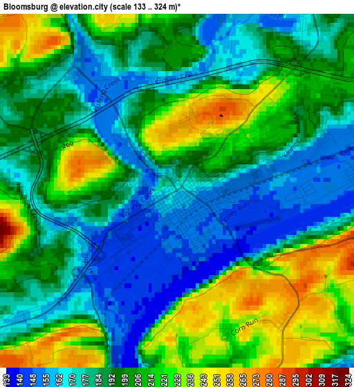
Below is the Elevation map of Bloomsburg, which displays elevation range with different colors. Scale of the first map is from 133 to 324 m (436 to 1063 ft) with average elevation of 196.1 meters (=643 ft) [note 1]
These maps also provides idea of topography and contour of this city, they are displayed at different zoom levels. More info about maps, scale and edge coordinates you can find below images.
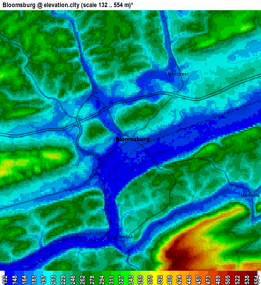
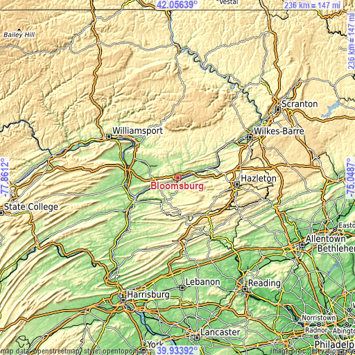
| \ | Map #1 | Map #2 | Topo.Map |
| Scale [m] | 133..324 m | 132..554 m | × |
| Scale [ft] | 436..1063 ft | 433..1818 ft | × |
| Average | 196.1 m = 643 ft | 234.2 m = 768 ft | × |
| Width | 7.37 km = 4.6 mi | 14.75 km = 9.2 mi | 236 km = 146.6 mi |
| Height | 7.37 km = 4.6 mi | 14.75 km = 9.2 mi | 236 km = 146.6 mi |
| ↑Max Latitude | 41.036856° | 41.069995° | 42.05639° |
| Latitude at center | 41.0037° | 41.0037° | 41.0037° |
| ↓Min Latitude | 40.970528° | 40.937338° | 39.93392° |
| ← Min Longitude | -76.498895° | -76.542841° | -77.8612° |
| Longitude center | -76.45495° | -76.45495° | -76.45495° |
| →Max Longitude | -76.411005° | -76.367059° | -75.0487° |
Nearby cities:
Cities around Bloomsburg sort by population:
• Berwick elevation 162 m
19.4 km,  73°
73°
• Danville 146 m
14 km,  251°
251°
• Mechanicsville 181 m
11.8 km, 249°
• Elysburg 180 m
17.5 km,  207°
207°
• East Berwick 177 m
20.6 km, 71°
• Riverside 158 m
15.6 km, 249°
• Espy 150 m
3.8 km,  85°
85°
• Nescopeck 157 m
20.4 km, 74°
• Catawissa 160 m
5.8 km,  183°
183°
• Mifflinville 156 m
12.7 km,  75°
75°
• Light Street 167 m
4.5 km,  36°
36°
• Almedia 152 m
6.3 km, 79°
Multilingual:
 En español:
Bloomsburg elevación 165 m.
 En France:
Bloomsburg élévation 165 m.
 Auf Deutsch:
Bloomsburg höhe über dem Meeresspiegel ist 165 m.

Sources and notes:
- [note 1] Map square and city borders are not equal. Map elevation data is calculated only from area inside that square.
- [src 1] Elevation data from geonames database provided with same terms of usage.
- [src 2] The elevation map of Bloomsburg is generated using elevation data from NASA's 3 arcsec (90m) resolution SRTM data.
- [src 3] Base (background) map © OpenStreetMap contributors tiles are generated by Geofabrik and OpenTopoMap.
Copyright & License:
This Bloomsburg Elevation Map is licensed under CC BY-SA. You may reuse any part from this page, if you give a proper credit by linking to this URL:
 More info on terms of use page.