Elysburg elevation
Elysburg (Pennsylvania, Northumberland County), United States elevation is 180 meters and Elysburg elevation in feet is 591 ft above sea level [src 1]. Elysburg is a populated place (feature code) with elevation that is 99 meters (325 ft) smaller than average city elevation in United States.
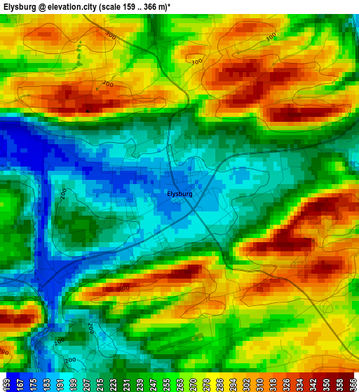
Below is the Elevation map of Elysburg, which displays elevation range with different colors. Scale of the first map is from 159 to 366 m (522 to 1201 ft) with average elevation of 252.9 meters (=830 ft) [note 1]
These maps also provides idea of topography and contour of this city, they are displayed at different zoom levels. More info about maps, scale and edge coordinates you can find below images.
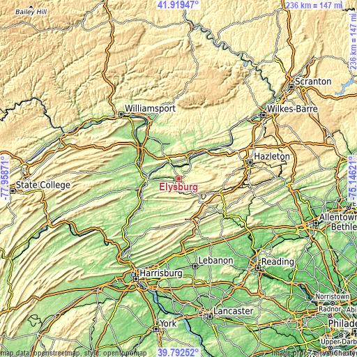
| \ | Map #1 | Topo.Map |
| Scale [m] | 159..366 m | × |
| Scale [ft] | 522..1201 ft | × |
| Average | 252.9 m = 830 ft | × |
| Width | 7.39 km = 4.6 mi | 236.5 km = 147 mi |
| Height | 7.39 km = 4.6 mi | 236.5 km = 147 mi |
| ↑Max Latitude | 40.897756° | 41.91947° |
| Latitude at center | 40.86453° | 40.86453° |
| ↓Min Latitude | 40.831288° | 39.79252° |
| ← Min Longitude | -76.596405° | -77.95871° |
| Longitude center | -76.55246° | -76.55246° |
| →Max Longitude | -76.508515° | -75.14621° |
Nearby cities:
Cities around Elysburg sort by population:
• Bloomsburg elevation 165 m
17.5 km,  27°
27°
• Shamokin 219 m
8.4 km,  183°
183°
• Mount Carmel 338 m
14 km,  122°
122°
• Danville 146 m
12.1 km,  335°
335°
• Mechanicsville 181 m
11.7 km,  345°
345°
• Kulpmont 341 m
10.4 km,  139°
139°
• Edgewood 243 m
8.6 km,  191°
191°
• Fairview-Ferndale 301 m
9.6 km, 191°
• Riverside 158 m
12 km,  327°
327°
• Trevorton 260 m
13.7 km,  227°
227°
• Catawissa 160 m
12.5 km,  38°
38°
• Marshallton 269 m
8.7 km,  172°
172°
Multilingual:
 En español:
Elysburg elevación 180 m.
 En France:
Elysburg élévation 180 m.
 Auf Deutsch:
Elysburg höhe über dem Meeresspiegel ist 180 m.

Sources and notes:
- [note 1] Map square and city borders are not equal. Map elevation data is calculated only from area inside that square.
- [src 1] Elevation data from geonames database provided with same terms of usage.
- [src 2] The elevation map of Elysburg is generated using elevation data from NASA's 3 arcsec (90m) resolution SRTM data.
- [src 3] Base (background) map © OpenStreetMap contributors tiles are generated by Geofabrik and OpenTopoMap.
Copyright & License:
This Elysburg Elevation Map is licensed under CC BY-SA. You may reuse any part from this page, if you give a proper credit by linking to this URL:
 More info on terms of use page.