Berwick elevation
Berwick (Pennsylvania, Columbia County), United States elevation is 162 meters and Berwick elevation in feet is 531 ft above sea level [src 1]. Berwick is a populated place (feature code) with elevation that is 117 meters (384 ft) smaller than average city elevation in United States.
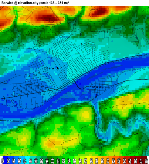
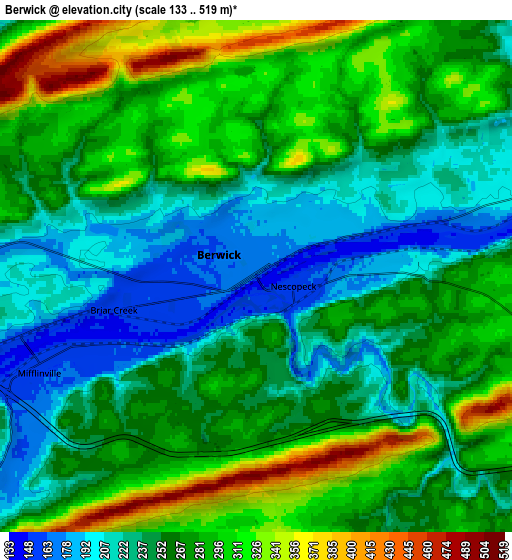
Below is the Elevation map of Berwick, which displays elevation range with different colors. Scale of the first map is from 133 to 381 m (436 to 1250 ft) with average elevation of 208.2 meters (=683 ft) [note 1]
These maps also provides idea of topography and contour of this city, they are displayed at different zoom levels. More info about maps, scale and edge coordinates you can find below images.
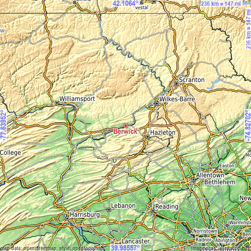
| \ | Map #1 | Map #2 | Topo.Map |
| Scale [m] | 133..381 m | 133..519 m | × |
| Scale [ft] | 436..1250 ft | 436..1703 ft | × |
| Average | 208.2 m = 683 ft | 263.7 m = 865 ft | × |
| Width | 7.37 km = 4.6 mi | 14.74 km = 9.2 mi | 235.8 km = 146.5 mi |
| Height | 7.37 km = 4.6 mi | 14.74 km = 9.2 mi | 235.8 km = 146.5 mi |
| ↑Max Latitude | 41.08766° | 41.120774° | 42.1064° |
| Latitude at center | 41.05453° | 41.05453° | 41.05453° |
| ↓Min Latitude | 41.021383° | 40.98822° | 39.98557° |
| ← Min Longitude | -76.277215° | -76.321161° | -77.63952° |
| Longitude center | -76.23327° | -76.23327° | -76.23327° |
| →Max Longitude | -76.189325° | -76.145379° | -74.82702° |
Nearby cities:
Cities around Berwick sort by population:
• Bloomsburg elevation 165 m
19.4 km,  253°
253°
• West Hazleton 518 m
22.6 km,  118°
118°
• East Berwick 177 m
1.2 km,  47°
47°
• Conyngham 297 m
16.4 km, 115°
• Glen Lyon 208 m
18.9 km,  44°
44°
• Espy 150 m
15.8 km, 250°
• Nescopeck 157 m
1.1 km,  104°
104°
• Catawissa 160 m
22.2 km,  239°
239°
• Mifflinville 156 m
6.7 km, 248°
• Harleigh 473 m
23.5 km,  110°
110°
• Light Street 167 m
16.1 km,  262°
262°
• Almedia 152 m
13.2 km, 250°
Multilingual:
 En español:
Berwick elevación 162 m.
 En France:
Berwick élévation 162 m.


Sources and notes:
- [note 1] Map square and city borders are not equal. Map elevation data is calculated only from area inside that square.
- [src 1] Elevation data from geonames database provided with same terms of usage.
- [src 2] The elevation map of Berwick is generated using elevation data from NASA's 3 arcsec (90m) resolution SRTM data.
- [src 3] Base (background) map © OpenStreetMap contributors tiles are generated by Geofabrik and OpenTopoMap.
Copyright & License:
This Berwick Elevation Map is licensed under CC BY-SA. You may reuse any part from this page, if you give a proper credit by linking to this URL:
 More info on terms of use page.