Bedminster elevation
Bedminster (Pennsylvania, Bucks County), United States elevation is 133 meters and Bedminster elevation in feet is 436 ft above sea level [src 1]. Bedminster is a populated place (feature code) with elevation that is 146 meters (479 ft) smaller than average city elevation in United States.
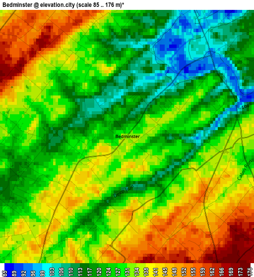
Below is the Elevation map of Bedminster, which displays elevation range with different colors. Scale of the first map is from 85 to 176 m (279 to 577 ft) with average elevation of 129.6 meters (=425 ft) [note 1]
These maps also provides idea of topography and contour of this city, they are displayed at different zoom levels. More info about maps, scale and edge coordinates you can find below images.
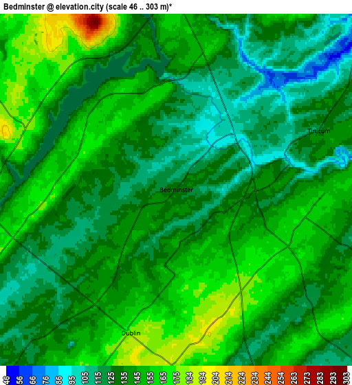
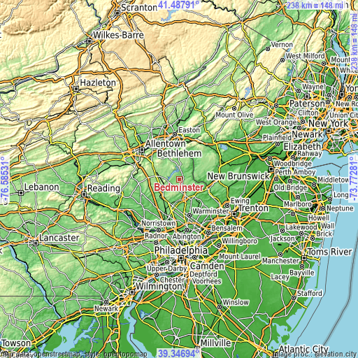
| \ | Map #1 | Map #2 | Topo.Map |
| Scale [m] | 85..176 m | 46..303 m | × |
| Scale [ft] | 279..577 ft | 151..994 ft | × |
| Average | 129.6 m = 425 ft | 138.6 m = 455 ft | × |
| Width | 7.44 km = 4.6 mi | 14.88 km = 9.2 mi | 238.1 km = 147.9 mi |
| Height | 7.44 km = 4.6 mi | 14.88 km = 9.2 mi | 238 km = 147.9 mi |
| ↑Max Latitude | 40.459385° | 40.492813° | 41.48791° |
| Latitude at center | 40.42594° | 40.42594° | 40.42594° |
| ↓Min Latitude | 40.392479° | 40.359° | 39.34694° |
| ← Min Longitude | -75.223005° | -75.266951° | -76.58531° |
| Longitude center | -75.17906° | -75.17906° | -75.17906° |
| →Max Longitude | -75.135115° | -75.091169° | -73.77281° |
Nearby cities:
Cities around Bedminster sort by population:
• Quakertown elevation 157 m
13.9 km,  277°
277°
• Perkasie 115 m
11.3 km,  238°
238°
• Doylestown 131 m
13.5 km,  162°
162°
• Telford 136 m
17.1 km,  227°
227°
• Tinicum 122 m
6.5 km,  67°
67°
• Sellersville 108 m
13.3 km, 233°
• Chalfont 87 m
15.5 km,  189°
189°
• New Britain 93 m
14.1 km,  180°
180°
• Plumsteadville 181 m
5.1 km,  147°
147°
• Dublin 176 m
6.3 km,  197°
197°
• Frenchtown 42 m
14.9 km,  41°
41°
• Richlandtown 167 m
12.9 km,  292°
292°
Multilingual:
 En español:
Bedminster elevación 133 m.
 En France:
Bedminster élévation 133 m.
 Auf Deutsch:
Bedminster höhe über dem Meeresspiegel ist 133 m.

Sources and notes:
- [note 1] Map square and city borders are not equal. Map elevation data is calculated only from area inside that square.
- [src 1] Elevation data from geonames database provided with same terms of usage.
- [src 2] The elevation map of Bedminster is generated using elevation data from NASA's 3 arcsec (90m) resolution SRTM data.
- [src 3] Base (background) map © OpenStreetMap contributors tiles are generated by Geofabrik and OpenTopoMap.
Copyright & License:
This Bedminster Elevation Map is licensed under CC BY-SA. You may reuse any part from this page, if you give a proper credit by linking to this URL:
 More info on terms of use page.