Richwood elevation
Richwood (Ohio, Union County), United States elevation is 288 meters and Richwood elevation in feet is 945 ft above sea level [src 1]. Richwood is a populated place (feature code) with elevation that is 9 meters (30 ft) bigger than average city elevation in United States.
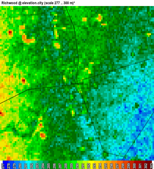
Below is the Elevation map of Richwood, which displays elevation range with different colors. Scale of the first map is from 277 to 300 m (909 to 984 ft) with average elevation of 285.5 meters (=937 ft) [note 1]
These maps also provides idea of topography and contour of this city, they are displayed at different zoom levels. More info about maps, scale and edge coordinates you can find below images.
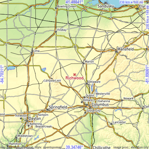
| \ | Map #1 | Topo.Map |
| Scale [m] | 277..300 m | × |
| Scale [ft] | 909..984 ft | × |
| Average | 285.5 m = 937 ft | × |
| Width | 7.44 km = 4.6 mi | 238.1 km = 147.9 mi |
| Height | 7.44 km = 4.6 mi | 238 km = 147.9 mi |
| ↑Max Latitude | 40.459895° | 41.48841° |
| Latitude at center | 40.42645° | 40.42645° |
| ↓Min Latitude | 40.392989° | 39.34746° |
| ← Min Longitude | -83.340805° | -84.70311° |
| Longitude center | -83.29686° | -83.29686° |
| →Max Longitude | -83.252915° | -81.89061° |
Nearby cities:
Cities around Richwood sort by population:
• Delaware elevation 262 m
24 km,  126°
126°
• Marion 301 m
23 km,  38°
38°
• Marysville 303 m
21.9 km,  195°
195°
• Powell 277 m
35.3 km,  147°
147°
• Lewis Center 285 m
35.1 km,  136°
136°
• Kenton 297 m
36.1 km,  312°
312°
• Plain City 282 m
35.5 km,  175°
175°
• Cardington 305 m
35.1 km,  76°
76°
• North Lewisburg 331 m
31.6 km,  224°
224°
• New California 303 m
30.5 km,  170°
170°
• Ashley 299 m
29 km,  93°
93°
• Prospect 275 m
9.5 km,  73°
73°
Multilingual:
 En español:
Richwood elevación 288 m.
 En France:
Richwood élévation 288 m.
 Auf Deutsch:
Richwood höhe über dem Meeresspiegel ist 288 m.

Sources and notes:
- [note 1] Map square and city borders are not equal. Map elevation data is calculated only from area inside that square.
- [src 1] Elevation data from geonames database provided with same terms of usage.
- [src 2] The elevation map of Richwood is generated using elevation data from NASA's 3 arcsec (90m) resolution SRTM data.
- [src 3] Base (background) map © OpenStreetMap contributors tiles are generated by Geofabrik and OpenTopoMap.
Copyright & License:
This Richwood Elevation Map is licensed under CC BY-SA. You may reuse any part from this page, if you give a proper credit by linking to this URL:
 More info on terms of use page.