Kenton elevation
Kenton (Ohio, Hardin County), United States elevation is 297 meters and Kenton elevation in feet is 974 ft above sea level [src 1]. Kenton is a seat of a second-order administrative division (feature code) with elevation that is 18 meters (59 ft) bigger than average city elevation in United States.
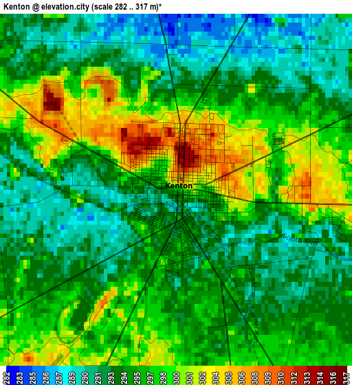
Below is the Elevation map of Kenton, which displays elevation range with different colors. Scale of the first map is from 282 to 317 m (925 to 1040 ft) with average elevation of 295.6 meters (=970 ft) [note 1]
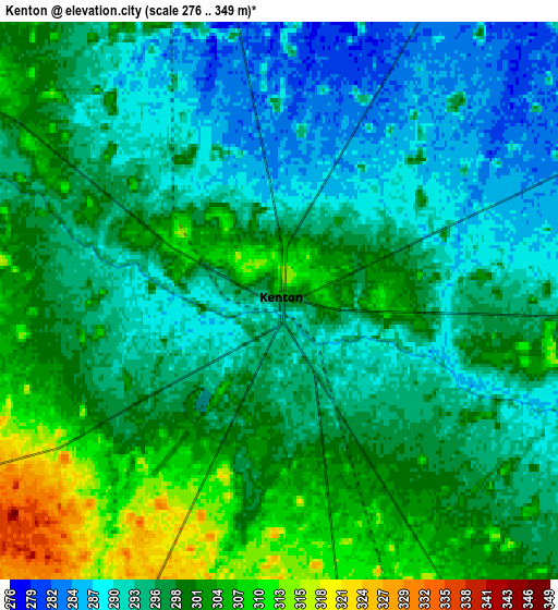
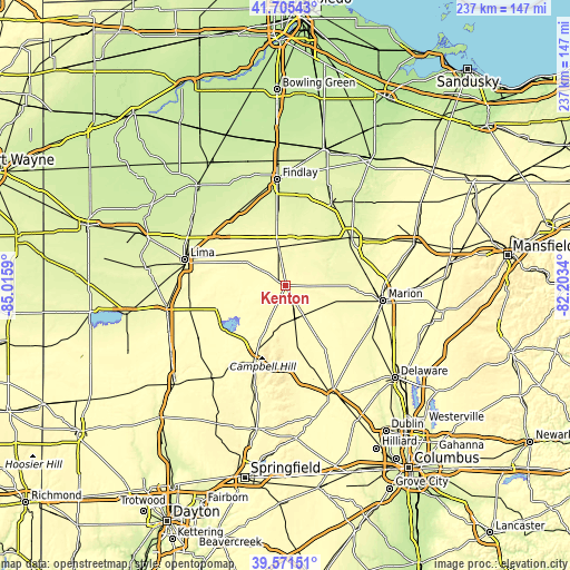
These maps also provides idea of topography and contour of this city, they are displayed at different zoom levels. More info about maps, scale and edge coordinates you can find below images.
| \ | Map #1 | Map #2 | Topo.Map |
| Scale [m] | 282..317 m | 276..349 m | × |
| Scale [ft] | 925..1040 ft | 906..1145 ft | × |
| Average | 295.6 m = 970 ft | 297.2 m = 975 ft | × |
| Width | 7.41 km = 4.6 mi | 14.83 km = 9.2 mi | 237.3 km = 147.5 mi |
| Height | 7.41 km = 4.6 mi | 14.83 km = 9.2 mi | 237.3 km = 147.5 mi |
| ↑Max Latitude | 40.680335° | 40.713653° | 41.70543° |
| Latitude at center | 40.647° | 40.647° | 40.647° |
| ↓Min Latitude | 40.613649° | 40.580281° | 39.57151° |
| ← Min Longitude | -83.653595° | -83.697541° | -85.0159° |
| Longitude center | -83.60965° | -83.60965° | -83.60965° |
| →Max Longitude | -83.565705° | -83.521759° | -82.2034° |
Nearby cities:
Cities around Kenton sort by population:
• Marion elevation 301 m
41.1 km,  99°
99°
• Bellefontaine 381 m
34.2 km,  201°
201°
• Upper Sandusky 260 m
34.2 km,  54°
54°
• Ada 291 m
22.5 km,  307°
307°
• Northwood 350 m
22 km,  208°
208°
• Bluffton 258 m
36.3 km,  319°
319°
• Carey 251 m
39 km,  29°
29°
• Richwood 288 m
36.1 km,  132°
132°
• Arlington 265 m
27.6 km,  352°
352°
• Forest 284 m
19.1 km, 25°
• Russells Point 306 m
30.9 km,  230°
230°
• Lakeview 301 m
32 km,  235°
235°
Multilingual:
 En español:
Kenton elevación 297 m.
 En France:
Kenton élévation 297 m.


Sources and notes:
- [note 1] Map square and city borders are not equal. Map elevation data is calculated only from area inside that square.
- [src 1] Elevation data from geonames database provided with same terms of usage.
- [src 2] The elevation map of Kenton is generated using elevation data from NASA's 3 arcsec (90m) resolution SRTM data.
- [src 3] Base (background) map © OpenStreetMap contributors tiles are generated by Geofabrik and OpenTopoMap.
Copyright & License:
This Kenton Elevation Map is licensed under CC BY-SA. You may reuse any part from this page, if you give a proper credit by linking to this URL:
 More info on terms of use page.