Upper Sandusky elevation
Upper Sandusky (Ohio, Wyandot County), United States elevation is 260 meters and Upper Sandusky elevation in feet is 853 ft above sea level [src 1]. Upper Sandusky is a seat of a second-order administrative division (feature code) with elevation that is 19 meters (62 ft) smaller than average city elevation in United States.
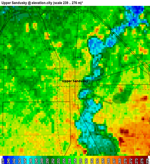
Below is the Elevation map of Upper Sandusky, which displays elevation range with different colors. Scale of the first map is from 239 to 276 m (784 to 906 ft) with average elevation of 256.4 meters (=841 ft) [note 1]
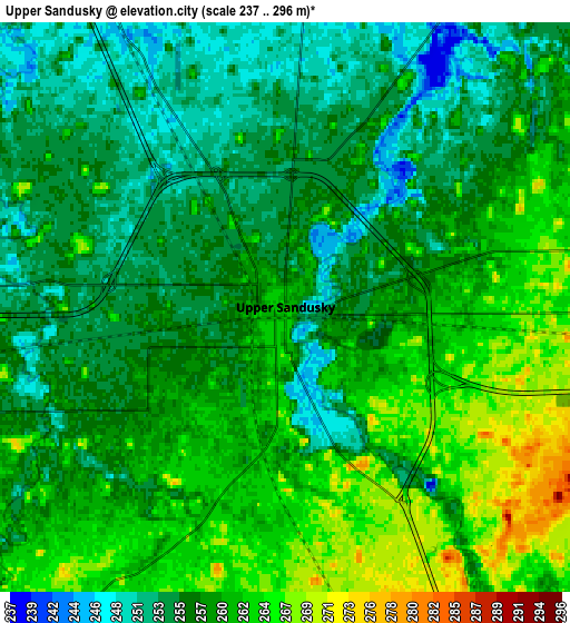
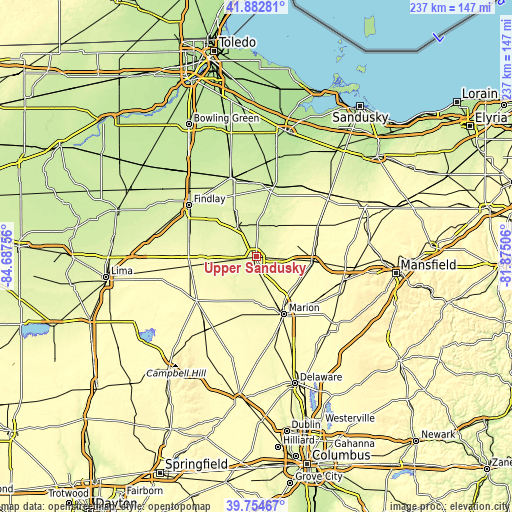
These maps also provides idea of topography and contour of this city, they are displayed at different zoom levels. More info about maps, scale and edge coordinates you can find below images.
| \ | Map #1 | Map #2 | Topo.Map |
| Scale [m] | 239..276 m | 237..296 m | × |
| Scale [ft] | 784..906 ft | 778..971 ft | × |
| Average | 256.4 m = 841 ft | 258.1 m = 847 ft | × |
| Width | 7.39 km = 4.6 mi | 14.79 km = 9.2 mi | 236.6 km = 147 mi |
| Height | 7.39 km = 4.6 mi | 14.79 km = 9.2 mi | 236.6 km = 147 mi |
| ↑Max Latitude | 40.860524° | 40.893752° | 41.88281° |
| Latitude at center | 40.82728° | 40.82728° | 40.82728° |
| ↓Min Latitude | 40.794019° | 40.760741° | 39.75467° |
| ← Min Longitude | -83.325255° | -83.369201° | -84.68756° |
| Longitude center | -83.28131° | -83.28131° | -83.28131° |
| →Max Longitude | -83.237365° | -83.193419° | -81.87506° |
Nearby cities:
Cities around Upper Sandusky sort by population:
• Findlay elevation 238 m
39.2 km,  307°
307°
• Marion 301 m
29.5 km,  154°
154°
• Tiffin 227 m
33.1 km,  15°
15°
• Fostoria 239 m
38.4 km,  342°
342°
• Bucyrus 302 m
25.8 km,  94°
94°
• Galion 356 m
42.7 km,  104°
104°
• Kenton 297 m
34.2 km,  234°
234°
• Carey 251 m
16.3 km,  328°
328°
• Richwood 288 m
44.6 km,  181°
181°
• Arlington 265 m
31.9 km,  283°
283°
• Forest 284 m
19.5 km,  261°
261°
• Prospect 275 m
42.6 km,  169°
169°
Multilingual:
 En español:
Upper Sandusky elevación 260 m.
 En France:
Upper Sandusky élévation 260 m.
 Auf Deutsch:
Upper Sandusky höhe über dem Meeresspiegel ist 260 m.

Sources and notes:
- [note 1] Map square and city borders are not equal. Map elevation data is calculated only from area inside that square.
- [src 1] Elevation data from geonames database provided with same terms of usage.
- [src 2] The elevation map of Upper Sandusky is generated using elevation data from NASA's 3 arcsec (90m) resolution SRTM data.
- [src 3] Base (background) map © OpenStreetMap contributors tiles are generated by Geofabrik and OpenTopoMap.
Copyright & License:
This Upper Sandusky Elevation Map is licensed under CC BY-SA. You may reuse any part from this page, if you give a proper credit by linking to this URL:
 More info on terms of use page.