Orwell elevation
Orwell (Ohio, Ashtabula County), United States elevation is 272 meters and Orwell elevation in feet is 892 ft above sea level [src 1]. Orwell is a populated place (feature code) with elevation that is 7 meters (23 ft) smaller than average city elevation in United States.
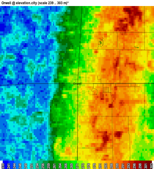
Below is the Elevation map of Orwell, which displays elevation range with different colors. Scale of the first map is from 239 to 303 m (784 to 994 ft) with average elevation of 267 meters (=876 ft) [note 1]
These maps also provides idea of topography and contour of this city, they are displayed at different zoom levels. More info about maps, scale and edge coordinates you can find below images.
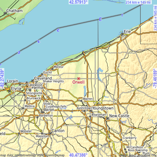
| \ | Map #1 | Topo.Map |
| Scale [m] | 239..303 m | × |
| Scale [ft] | 784..994 ft | × |
| Average | 267 m = 876 ft | × |
| Width | 7.32 km = 4.5 mi | 234.1 km = 145.5 mi |
| Height | 7.32 km = 4.5 mi | 234.1 km = 145.5 mi |
| ↑Max Latitude | 41.567947° | 42.57913° |
| Latitude at center | 41.53506° | 41.53506° |
| ↓Min Latitude | 41.502156° | 40.47386° |
| ← Min Longitude | -80.912085° | -82.27439° |
| Longitude center | -80.86814° | -80.86814° |
| →Max Longitude | -80.824195° | -79.46189° |
Nearby cities:
Cities around Orwell sort by population:
• Cortland elevation 312 m
25.7 km,  152°
152°
• Champion Heights 286 m
27.3 km,  176°
176°
• Geneva 206 m
30.7 km,  347°
347°
• Chardon 401 m
25 km,  290°
290°
• Madison 225 m
30.3 km,  330°
330°
• Jefferson 294 m
24.1 km,  19°
19°
• Middlefield 341 m
18.9 km,  244°
244°
• Leavittsburg 280 m
31.9 km, 181°
• Roaming Shores 266 m
12.6 km, 17°
• Burton 405 m
24.2 km,  252°
252°
• Morgandale 280 m
30.8 km,  166°
166°
• Andover 333 m
25.9 km,  72°
72°
Multilingual:
 En español:
Orwell elevación 272 m.
 En France:
Orwell élévation 272 m.


Sources and notes:
- [note 1] Map square and city borders are not equal. Map elevation data is calculated only from area inside that square.
- [src 1] Elevation data from geonames database provided with same terms of usage.
- [src 2] The elevation map of Orwell is generated using elevation data from NASA's 3 arcsec (90m) resolution SRTM data.
- [src 3] Base (background) map © OpenStreetMap contributors tiles are generated by Geofabrik and OpenTopoMap.
Copyright & License:
This Orwell Elevation Map is licensed under CC BY-SA. You may reuse any part from this page, if you give a proper credit by linking to this URL:
 More info on terms of use page.