Jefferson elevation
Jefferson (Ohio, Ashtabula County), United States elevation is 294 meters and Jefferson elevation in feet is 965 ft above sea level [src 1]. Jefferson is a seat of a second-order administrative division (feature code) with elevation that is 15 meters (49 ft) bigger than average city elevation in United States.
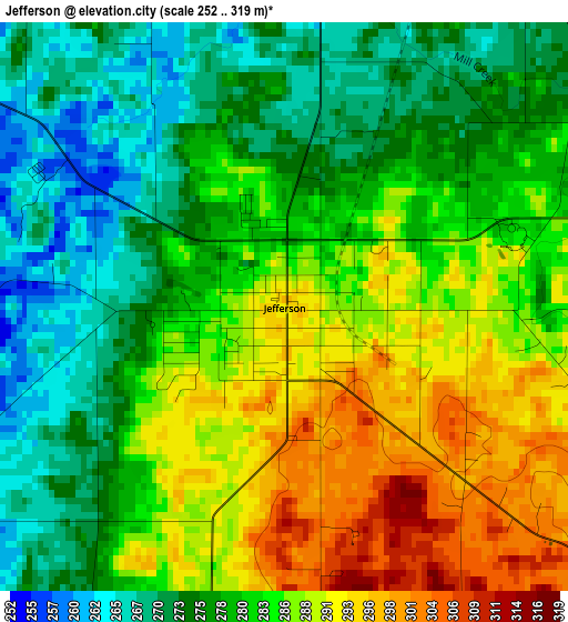
Below is the Elevation map of Jefferson, which displays elevation range with different colors. Scale of the first map is from 252 to 319 m (827 to 1047 ft) with average elevation of 281.6 meters (=924 ft) [note 1]
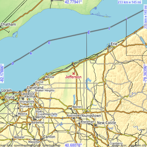
These maps also provides idea of topography and contour of this city, they are displayed at different zoom levels. More info about maps, scale and edge coordinates you can find below images.
| \ | Map #1 | Topo.Map |
| Scale [m] | 252..319 m | × |
| Scale [ft] | 827..1047 ft | × |
| Average | 281.6 m = 924 ft | × |
| Width | 7.29 km = 4.5 mi | 233.3 km = 145 mi |
| Height | 7.29 km = 4.5 mi | 233.3 km = 145 mi |
| ↑Max Latitude | 41.771453° | 42.77941° |
| Latitude at center | 41.73867° | 41.73867° |
| ↓Min Latitude | 41.70587° | 40.68078° |
| ← Min Longitude | -80.813755° | -82.17606° |
| Longitude center | -80.76981° | -80.76981° |
| →Max Longitude | -80.725865° | -79.36356° |
Nearby cities:
Cities around Jefferson sort by population:
• Ashtabula elevation 210 m
14.1 km,  353°
353°
• Conneaut 202 m
29.3 km,  37°
37°
• North Madison 206 m
24.2 km,  286°
286°
• Geneva 206 m
16.5 km,  296°
296°
• Edgewood 214 m
14.9 km,  359°
359°
• Madison 225 m
23.5 km,  278°
278°
• North Kingsville 217 m
19.7 km,  19°
19°
• Pymatuning Central 346 m
29.5 km,  125°
125°
• Orwell 272 m
24.1 km,  199°
199°
• Roaming Shores 266 m
11.5 km, 202°
• Geneva-on-the-Lake 189 m
20.3 km,  311°
311°
• Andover 333 m
22 km, 131°
Multilingual:
 En español:
Jefferson elevación 294 m.
 En France:
Jefferson élévation 294 m.
 Auf Deutsch:
Jefferson höhe über dem Meeresspiegel ist 294 m.

Sources and notes:
- [note 1] Map square and city borders are not equal. Map elevation data is calculated only from area inside that square.
- [src 1] Elevation data from geonames database provided with same terms of usage.
- [src 2] The elevation map of Jefferson is generated using elevation data from NASA's 3 arcsec (90m) resolution SRTM data.
- [src 3] Base (background) map © OpenStreetMap contributors tiles are generated by Geofabrik and OpenTopoMap.
Copyright & License:
This Jefferson Elevation Map is licensed under CC BY-SA. You may reuse any part from this page, if you give a proper credit by linking to this URL:
 More info on terms of use page.