Champion Heights elevation
Champion Heights (Ohio, Trumbull County), United States elevation is 286 meters and Champion Heights elevation in feet is 938 ft above sea level [src 1]. Champion Heights is a populated place (feature code) with elevation that is 7 meters (23 ft) bigger than average city elevation in United States.
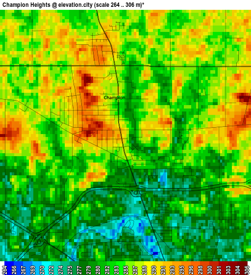
Below is the Elevation map of Champion Heights, which displays elevation range with different colors. Scale of the first map is from 264 to 306 m (866 to 1004 ft) with average elevation of 283.9 meters (=931 ft) [note 1]
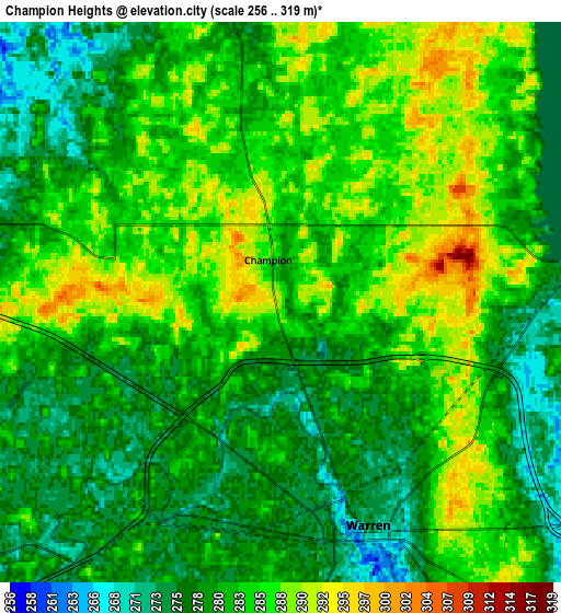
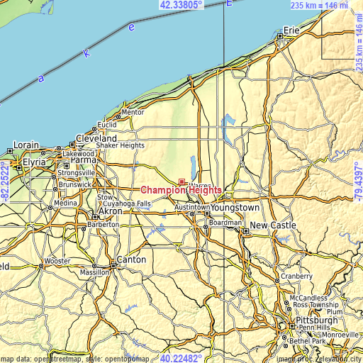
These maps also provides idea of topography and contour of this city, they are displayed at different zoom levels. More info about maps, scale and edge coordinates you can find below images.
| \ | Map #1 | Map #2 | Topo.Map |
| Scale [m] | 264..306 m | 256..319 m | × |
| Scale [ft] | 866..1004 ft | 840..1047 ft | × |
| Average | 283.9 m = 931 ft | 281.9 m = 925 ft | × |
| Width | 7.34 km = 4.6 mi | 14.69 km = 9.1 mi | 235 km = 146 mi |
| Height | 7.34 km = 4.6 mi | 14.69 km = 9.1 mi | 235 km = 146 mi |
| ↑Max Latitude | 41.323001° | 41.355996° | 42.33805° |
| Latitude at center | 41.28999° | 41.28999° | 41.28999° |
| ↓Min Latitude | 41.256962° | 41.223917° | 40.22482° |
| ← Min Longitude | -80.889895° | -80.933841° | -82.2522° |
| Longitude center | -80.84595° | -80.84595° | -80.84595° |
| →Max Longitude | -80.802005° | -80.758059° | -79.4397° |
Nearby cities:
Cities around Champion Heights sort by population:
• Warren elevation 275 m
6.3 km,  158°
158°
• Niles 271 m
13.7 km,  150°
150°
• Cortland 312 m
11 km,  65°
65°
• Howland Center 271 m
9.4 km,  117°
117°
• Newton Falls 282 m
15.8 km,  224°
224°
• Lordstown 291 m
13.9 km,  184°
184°
• McDonald 293 m
17.3 km,  144°
144°
• Bolindale 292 m
10.8 km, 148°
• Leavittsburg 280 m
5.4 km,  208°
208°
• Morgandale 280 m
5.9 km, 117°
• South Canal 294 m
17.2 km, 223°
• McKinley Heights 300 m
16 km, 137°
Multilingual:
 En español:
Champion Heights elevación 286 m.
 En France:
Champion Heights élévation 286 m.
 Auf Deutsch:
Champion Heights höhe über dem Meeresspiegel ist 286 m.

Sources and notes:
- [note 1] Map square and city borders are not equal. Map elevation data is calculated only from area inside that square.
- [src 1] Elevation data from geonames database provided with same terms of usage.
- [src 2] The elevation map of Champion Heights is generated using elevation data from NASA's 3 arcsec (90m) resolution SRTM data.
- [src 3] Base (background) map © OpenStreetMap contributors tiles are generated by Geofabrik and OpenTopoMap.
Copyright & License:
This Champion Heights Elevation Map is licensed under CC BY-SA. You may reuse any part from this page, if you give a proper credit by linking to this URL:
 More info on terms of use page.