Frazeysburg elevation
Frazeysburg (Ohio, Muskingum County), United States elevation is 229 meters and Frazeysburg elevation in feet is 751 ft above sea level [src 1]. Frazeysburg is a populated place (feature code) with elevation that is 50 meters (164 ft) smaller than average city elevation in United States.
Below is the Elevation map of Frazeysburg, which displays elevation range with different colors. Scale of the first map is from 217 to 329 m (712 to 1079 ft) with average elevation of 260.5 meters (=855 ft) [note 1]
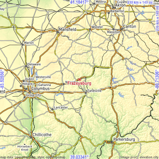
These maps also provides idea of topography and contour of this city, they are displayed at different zoom levels. More info about maps, scale and edge coordinates you can find below images.
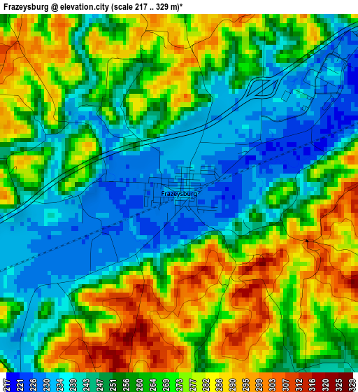
| \ | Map #1 | Topo.Map |
| Scale [m] | 217..329 m | × |
| Scale [ft] | 712..1079 ft | × |
| Average | 260.5 m = 855 ft | × |
| Width | 7.47 km = 4.6 mi | 239.1 km = 148.6 mi |
| Height | 7.47 km = 4.6 mi | 239.1 km = 148.6 mi |
| ↑Max Latitude | 40.150888° | 41.18417° |
| Latitude at center | 40.11729° | 40.11729° |
| ↓Min Latitude | 40.083676° | 39.03341° |
| ← Min Longitude | -82.163255° | -83.52556° |
| Longitude center | -82.11931° | -82.11931° |
| →Max Longitude | -82.075365° | -80.71306° |
Nearby cities:
Cities around Frazeysburg sort by population:
• Newark elevation 260 m
24.9 km,  254°
254°
• Zanesville 207 m
21.6 km,  155°
155°
• Coshocton 234 m
28 km,  52°
52°
• Heath 263 m
29.6 km, 249°
• North Zanesville 272 m
18.3 km,  147°
147°
• Utica 295 m
31.1 km,  294°
294°
• South Zanesville 221 m
26.1 km, 158°
• Pleasant Grove 288 m
22.9 km,  143°
143°
• Dresden 227 m
9.2 km,  87°
87°
• Harbor Hills 282 m
33.6 km,  233°
233°
• Hanover 252 m
12.8 km, 250°
• Thornport 270 m
33.6 km, 227°
Multilingual:
 En español:
Frazeysburg elevación 229 m.
 En France:
Frazeysburg élévation 229 m.
 Auf Deutsch:
Frazeysburg höhe über dem Meeresspiegel ist 229 m.

Sources and notes:
- [note 1] Map square and city borders are not equal. Map elevation data is calculated only from area inside that square.
- [src 1] Elevation data from geonames database provided with same terms of usage.
- [src 2] The elevation map of Frazeysburg is generated using elevation data from NASA's 3 arcsec (90m) resolution SRTM data.
- [src 3] Base (background) map © OpenStreetMap contributors tiles are generated by Geofabrik and OpenTopoMap.
Copyright & License:
This Frazeysburg Elevation Map is licensed under CC BY-SA. You may reuse any part from this page, if you give a proper credit by linking to this URL:
 More info on terms of use page.