Zanesville elevation
Zanesville (Ohio, Muskingum County), United States elevation is 207 meters and Zanesville elevation in feet is 679 ft above sea level [src 1]. Zanesville is a seat of a second-order administrative division (feature code) with elevation that is 72 meters (236 ft) smaller than average city elevation in United States.
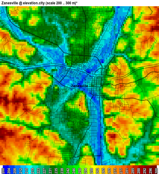
Below is the Elevation map of Zanesville, which displays elevation range with different colors. Scale of the first map is from 200 to 300 m (656 to 984 ft) with average elevation of 244.6 meters (=802 ft) [note 1]
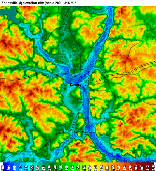
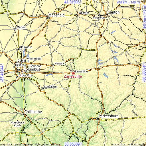
These maps also provides idea of topography and contour of this city, they are displayed at different zoom levels. More info about maps, scale and edge coordinates you can find below images.
| \ | Map #1 | Map #2 | Topo.Map |
| Scale [m] | 200..300 m | 200..316 m | × |
| Scale [ft] | 656..984 ft | 656..1037 ft | × |
| Average | 244.6 m = 802 ft | 255.2 m = 837 ft | × |
| Width | 7.49 km = 4.7 mi | 14.99 km = 9.3 mi | 239.8 km = 149 mi |
| Height | 7.49 km = 4.7 mi | 14.99 km = 9.3 mi | 239.8 km = 149 mi |
| ↑Max Latitude | 39.974035° | 40.007704° | 41.01003° |
| Latitude at center | 39.94035° | 39.94035° | 39.94035° |
| ↓Min Latitude | 39.906648° | 39.87293° | 38.85369° |
| ← Min Longitude | -82.057135° | -82.101081° | -83.41944° |
| Longitude center | -82.01319° | -82.01319° | -82.01319° |
| →Max Longitude | -81.969245° | -81.925299° | -80.60694° |
Nearby cities:
Cities around Zanesville sort by population:
• New Lexington elevation 293 m
30.2 km,  213°
213°
• North Zanesville 272 m
4.3 km,  10°
10°
• Crooksville 239 m
20.2 km,  199°
199°
• New Concord 264 m
24.5 km,  76°
76°
• South Zanesville 221 m
4.6 km,  172°
172°
• Roseville 224 m
15.6 km, 198°
• Pleasant Grove 288 m
4.8 km,  74°
74°
• Dresden 227 m
20.1 km,  0°
0°
• Somerset 330 m
28.4 km,  238°
238°
• Frazeysburg 229 m
21.6 km,  335°
335°
• Hanover 252 m
26.2 km,  306°
306°
• Mantua 318 m
32.3 km,  61°
61°
Multilingual:
 En español:
Zanesville elevación 207 m.
 En France:
Zanesville élévation 207 m.
 Auf Deutsch:
Zanesville höhe über dem Meeresspiegel ist 207 m.

Sources and notes:
- [note 1] Map square and city borders are not equal. Map elevation data is calculated only from area inside that square.
- [src 1] Elevation data from geonames database provided with same terms of usage.
- [src 2] The elevation map of Zanesville is generated using elevation data from NASA's 3 arcsec (90m) resolution SRTM data.
- [src 3] Base (background) map © OpenStreetMap contributors tiles are generated by Geofabrik and OpenTopoMap.
Copyright & License:
This Zanesville Elevation Map is licensed under CC BY-SA. You may reuse any part from this page, if you give a proper credit by linking to this URL:
 More info on terms of use page.