Somerset elevation
Somerset (Ohio, Perry County), United States elevation is 330 meters and Somerset elevation in feet is 1083 ft above sea level [src 1]. Somerset is a populated place (feature code) with elevation that is 51 meters (167 ft) bigger than average city elevation in United States.
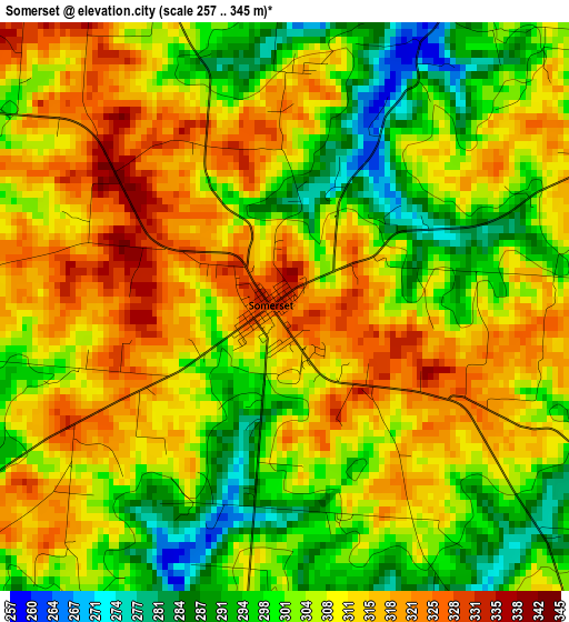
Below is the Elevation map of Somerset, which displays elevation range with different colors. Scale of the first map is from 257 to 345 m (843 to 1132 ft) with average elevation of 306.9 meters (=1007 ft) [note 1]
These maps also provides idea of topography and contour of this city, they are displayed at different zoom levels. More info about maps, scale and edge coordinates you can find below images.
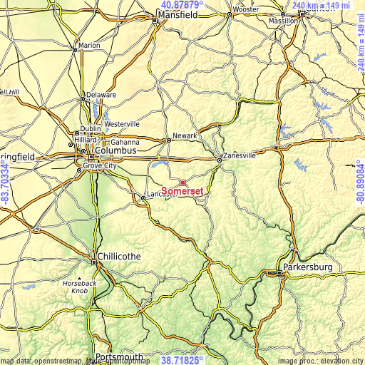
| \ | Map #1 | Topo.Map |
| Scale [m] | 257..345 m | × |
| Scale [ft] | 843..1132 ft | × |
| Average | 306.9 m = 1007 ft | × |
| Width | 7.51 km = 4.7 mi | 240.2 km = 149.3 mi |
| Height | 7.51 km = 4.7 mi | 240.2 km = 149.3 mi |
| ↑Max Latitude | 39.840761° | 40.87879° |
| Latitude at center | 39.80701° | 39.80701° |
| ↓Min Latitude | 39.773243° | 38.71825° |
| ← Min Longitude | -82.341035° | -83.70334° |
| Longitude center | -82.29709° | -82.29709° |
| →Max Longitude | -82.253145° | -80.89084° |
Nearby cities:
Cities around Somerset sort by population:
• Geneva elevation 303 m
19.9 km,  215°
215°
• New Lexington 293 m
12.8 km,  143°
143°
• Baltimore 261 m
26.3 km,  279°
279°
• Buckeye Lake 276 m
20.5 km,  313°
313°
• Crooksville 239 m
18 km,  103°
103°
• Hebron 266 m
23.9 km,  316°
316°
• Roseville 224 m
19.3 km,  89°
89°
• Harbor Hills 282 m
18.6 km, 320°
• Bremen 240 m
16.1 km, 223°
• Fairfield Beach 284 m
19.4 km, 308°
• Millersport 271 m
22.7 km,  297°
297°
• Thornport 270 m
15.3 km, 320°
Multilingual:
 En español:
Somerset elevación 330 m.
 En France:
Somerset élévation 330 m.
 Auf Deutsch:
Somerset höhe über dem Meeresspiegel ist 330 m.

Sources and notes:
- [note 1] Map square and city borders are not equal. Map elevation data is calculated only from area inside that square.
- [src 1] Elevation data from geonames database provided with same terms of usage.
- [src 2] The elevation map of Somerset is generated using elevation data from NASA's 3 arcsec (90m) resolution SRTM data.
- [src 3] Base (background) map © OpenStreetMap contributors tiles are generated by Geofabrik and OpenTopoMap.
Copyright & License:
This Somerset Elevation Map is licensed under CC BY-SA. You may reuse any part from this page, if you give a proper credit by linking to this URL:
 More info on terms of use page.