Heath elevation
Heath (Ohio, Licking County), United States elevation is 263 meters and Heath elevation in feet is 863 ft above sea level [src 1]. Heath is a populated place (feature code) with elevation that is 16 meters (52 ft) smaller than average city elevation in United States.
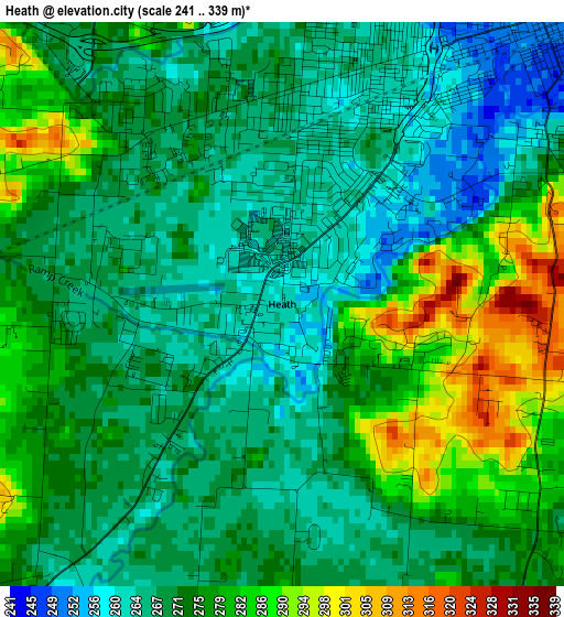
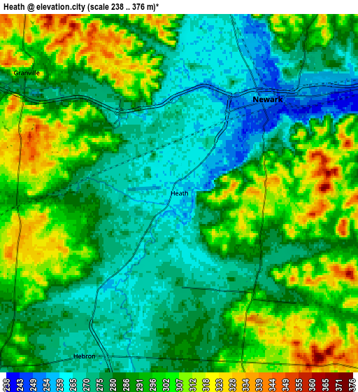
Below is the Elevation map of Heath, which displays elevation range with different colors. Scale of the first map is from 241 to 339 m (791 to 1112 ft) with average elevation of 272.9 meters (=895 ft) [note 1]
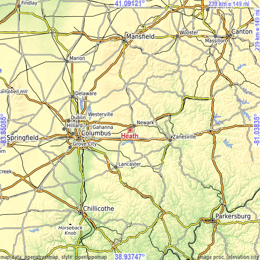
These maps also provides idea of topography and contour of this city, they are displayed at different zoom levels. More info about maps, scale and edge coordinates you can find below images.
| \ | Map #1 | Map #2 | Topo.Map |
| Scale [m] | 241..339 m | 238..376 m | × |
| Scale [ft] | 791..1112 ft | 781..1234 ft | × |
| Average | 272.9 m = 895 ft | 288 m = 945 ft | × |
| Width | 7.48 km = 4.6 mi | 14.97 km = 9.3 mi | 239.5 km = 148.8 mi |
| Height | 7.48 km = 4.6 mi | 14.97 km = 9.3 mi | 239.5 km = 148.8 mi |
| ↑Max Latitude | 40.056484° | 40.090112° | 41.09121° |
| Latitude at center | 40.02284° | 40.02284° | 40.02284° |
| ↓Min Latitude | 39.989179° | 39.955501° | 38.93747° |
| ← Min Longitude | -82.488545° | -82.532491° | -83.85085° |
| Longitude center | -82.4446° | -82.4446° | -82.4446° |
| →Max Longitude | -82.400655° | -82.356709° | -81.03835° |
Nearby cities:
Cities around Heath sort by population:
• Newark elevation 260 m
5.4 km,  43°
43°
• Pataskala 305 m
19.8 km,  261°
261°
• Granville 291 m
8.1 km,  308°
308°
• Beechwood Trails 375 m
17.6 km,  270°
270°
• Buckeye Lake 276 m
10.2 km,  193°
193°
• Hebron 266 m
7.9 km,  210°
210°
• Harbor Hills 282 m
9.6 km,  175°
175°
• Granville South 319 m
8.9 km,  291°
291°
• Fairfield Beach 284 m
12.2 km, 192°
• Hanover 252 m
16.9 km,  67°
67°
• Millersport 271 m
15.6 km, 209°
• Thornport 270 m
12.5 km,  166°
166°
Multilingual:
 En español:
Heath elevación 263 m.
 En France:
Heath élévation 263 m.


Sources and notes:
- [note 1] Map square and city borders are not equal. Map elevation data is calculated only from area inside that square.
- [src 1] Elevation data from geonames database provided with same terms of usage.
- [src 2] The elevation map of Heath is generated using elevation data from NASA's 3 arcsec (90m) resolution SRTM data.
- [src 3] Base (background) map © OpenStreetMap contributors tiles are generated by Geofabrik and OpenTopoMap.
Copyright & License:
This Heath Elevation Map is licensed under CC BY-SA. You may reuse any part from this page, if you give a proper credit by linking to this URL:
 More info on terms of use page.