Warsaw elevation
Warsaw (New York, Wyoming County), United States elevation is 310 meters and Warsaw elevation in feet is 1017 ft above sea level [src 1]. Warsaw is a seat of a second-order administrative division (feature code) with elevation that is 31 meters (102 ft) bigger than average city elevation in United States.
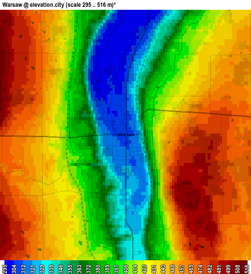
Below is the Elevation map of Warsaw, which displays elevation range with different colors. Scale of the first map is from 295 to 516 m (968 to 1693 ft) with average elevation of 417.8 meters (=1371 ft) [note 1]
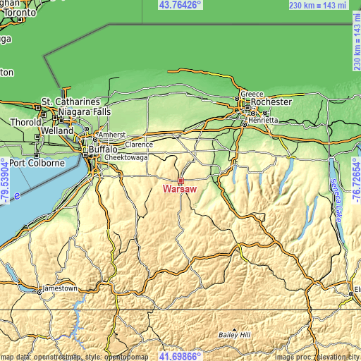
These maps also provides idea of topography and contour of this city, they are displayed at different zoom levels. More info about maps, scale and edge coordinates you can find below images.
| \ | Map #1 | Topo.Map |
| Scale [m] | 295..516 m | × |
| Scale [ft] | 968..1693 ft | × |
| Average | 417.8 m = 1371 ft | × |
| Width | 7.18 km = 4.5 mi | 229.7 km = 142.7 mi |
| Height | 7.18 km = 4.5 mi | 229.7 km = 142.7 mi |
| ↑Max Latitude | 42.772327° | 43.76426° |
| Latitude at center | 42.74006° | 42.74006° |
| ↓Min Latitude | 42.707776° | 41.69866° |
| ← Min Longitude | -78.176735° | -79.53904° |
| Longitude center | -78.13279° | -78.13279° |
| →Max Longitude | -78.088845° | -76.72654° |
Nearby cities:
Cities around Warsaw sort by population:
• Batavia elevation 272 m
29 km,  351°
351°
• Geneseo 238 m
26.5 km,  76°
76°
• Le Roy 279 m
29.1 km,  24°
24°
• Perry 419 m
10.7 km,  104°
104°
• Mount Morris 191 m
21.2 km,  94°
94°
• Alden 267 m
34.3 km,  301°
301°
• Attica 302 m
18.3 km,  318°
318°
• Caledonia 201 m
34.5 km,  41°
41°
• Arcade 452 m
33 km,  226°
226°
• Houghton 371 m
35.3 km,  183°
183°
• Nunda 289 m
23.7 km,  138°
138°
• Holland 339 m
35.2 km,  251°
251°
Multilingual:
 En español:
Warsaw elevación 310 m.
 En France:
Warsaw élévation 310 m.


Sources and notes:
- [note 1] Map square and city borders are not equal. Map elevation data is calculated only from area inside that square.
- [src 1] Elevation data from geonames database provided with same terms of usage.
- [src 2] The elevation map of Warsaw is generated using elevation data from NASA's 3 arcsec (90m) resolution SRTM data.
- [src 3] Base (background) map © OpenStreetMap contributors tiles are generated by Geofabrik and OpenTopoMap.
Copyright & License:
This Warsaw Elevation Map is licensed under CC BY-SA. You may reuse any part from this page, if you give a proper credit by linking to this URL:
 More info on terms of use page.