Mount Morris elevation
Mount Morris (New York, Livingston County), United States elevation is 191 meters and Mount Morris elevation in feet is 627 ft above sea level [src 1]. Mount Morris is a populated place (feature code) with elevation that is 88 meters (289 ft) smaller than average city elevation in United States.
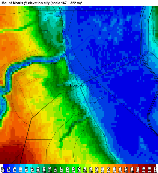
Below is the Elevation map of Mount Morris, which displays elevation range with different colors. Scale of the first map is from 167 to 322 m (548 to 1056 ft) with average elevation of 213.9 meters (=702 ft) [note 1]
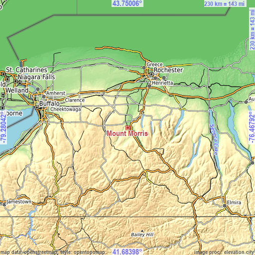
These maps also provides idea of topography and contour of this city, they are displayed at different zoom levels. More info about maps, scale and edge coordinates you can find below images.
| \ | Map #1 | Topo.Map |
| Scale [m] | 167..322 m | × |
| Scale [ft] | 548..1056 ft | × |
| Average | 213.9 m = 702 ft | × |
| Width | 7.18 km = 4.5 mi | 229.7 km = 142.7 mi |
| Height | 7.18 km = 4.5 mi | 229.7 km = 142.7 mi |
| ↑Max Latitude | 42.757894° | 43.75006° |
| Latitude at center | 42.72562° | 42.72562° |
| ↓Min Latitude | 42.693329° | 41.68398° |
| ← Min Longitude | -77.918115° | -79.28042° |
| Longitude center | -77.87417° | -77.87417° |
| →Max Longitude | -77.830225° | -76.46792° |
Nearby cities:
Cities around Mount Morris sort by population:
• Geneseo elevation 238 m
9.1 km,  30°
30°
• Dansville 218 m
23.4 km,  141°
141°
• Le Roy 279 m
29.5 km,  342°
342°
• Perry 419 m
10.8 km,  264°
264°
• Warsaw 310 m
21.2 km,  274°
274°
• Avon 200 m
23.2 km, 26°
• Honeoye Falls 203 m
34.2 km,  42°
42°
• Caledonia 201 m
27.6 km,  3°
3°
• Lima 253 m
29.3 km,  47°
47°
• Wayland 418 m
29.1 km,  127°
127°
• Livonia 315 m
19.9 km,  57°
57°
• Nunda 289 m
17.2 km,  198°
198°
Multilingual:
 En español:
Mount Morris elevación 191 m.
 En France:
Mount Morris élévation 191 m.
 Auf Deutsch:
Mount Morris höhe über dem Meeresspiegel ist 191 m.

Sources and notes:
- [note 1] Map square and city borders are not equal. Map elevation data is calculated only from area inside that square.
- [src 1] Elevation data from geonames database provided with same terms of usage.
- [src 2] The elevation map of Mount Morris is generated using elevation data from NASA's 3 arcsec (90m) resolution SRTM data.
- [src 3] Base (background) map © OpenStreetMap contributors tiles are generated by Geofabrik and OpenTopoMap.
Copyright & License:
This Mount Morris Elevation Map is licensed under CC BY-SA. You may reuse any part from this page, if you give a proper credit by linking to this URL:
 More info on terms of use page.