Lima elevation
Lima (New York, Livingston County), United States elevation is 253 meters and Lima elevation in feet is 830 ft above sea level [src 1]. Lima is a populated place (feature code) with elevation that is 26 meters (85 ft) smaller than average city elevation in United States.
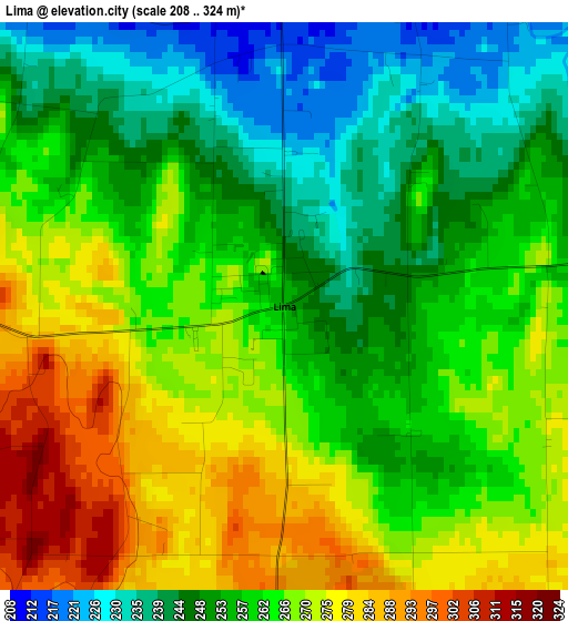
Below is the Elevation map of Lima, which displays elevation range with different colors. Scale of the first map is from 208 to 324 m (682 to 1063 ft) with average elevation of 260.4 meters (=854 ft) [note 1]
These maps also provides idea of topography and contour of this city, they are displayed at different zoom levels. More info about maps, scale and edge coordinates you can find below images.
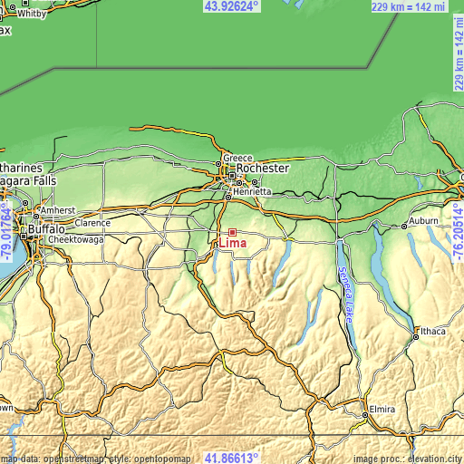
| \ | Map #1 | Topo.Map |
| Scale [m] | 208..324 m | × |
| Scale [ft] | 682..1063 ft | × |
| Average | 260.4 m = 854 ft | × |
| Width | 7.16 km = 4.4 mi | 229.1 km = 142.4 mi |
| Height | 7.16 km = 4.4 mi | 229.1 km = 142.4 mi |
| ↑Max Latitude | 42.936971° | 43.92624° |
| Latitude at center | 42.90479° | 42.90479° |
| ↓Min Latitude | 42.872592° | 41.86613° |
| ← Min Longitude | -77.655335° | -79.01764° |
| Longitude center | -77.61139° | -77.61139° |
| →Max Longitude | -77.567445° | -76.20514° |
Nearby cities:
Cities around Lima sort by population:
• Canandaigua elevation 243 m
26.6 km,  97°
97°
• Geneseo 238 m
20.7 km,  234°
234°
• East Rochester 138 m
24.8 km,  23°
23°
• Fairport 152 m
25.6 km,  32°
32°
• Avon 200 m
11 km,  274°
274°
• Victor 180 m
18.6 km,  62°
62°
• Honeoye Falls 203 m
5.6 km, 18°
• Caledonia 201 m
21.1 km,  291°
291°
• Scottsville 190 m
17.3 km,  321°
321°
• Holcomb 269 m
15.6 km,  91°
91°
• Livonia 315 m
10.4 km,  206°
206°
• Pittsford 150 m
22.1 km, 20°
Multilingual:
 En español:
Lima elevación 253 m.
 En France:
Lima élévation 253 m.


Sources and notes:
- [note 1] Map square and city borders are not equal. Map elevation data is calculated only from area inside that square.
- [src 1] Elevation data from geonames database provided with same terms of usage.
- [src 2] The elevation map of Lima is generated using elevation data from NASA's 3 arcsec (90m) resolution SRTM data.
- [src 3] Base (background) map © OpenStreetMap contributors tiles are generated by Geofabrik and OpenTopoMap.
Copyright & License:
This Lima Elevation Map is licensed under CC BY-SA. You may reuse any part from this page, if you give a proper credit by linking to this URL:
 More info on terms of use page.