Pittsford elevation
Pittsford (New York, Monroe County), United States elevation is 150 meters and Pittsford elevation in feet is 492 ft above sea level [src 1]. Pittsford is a populated place (feature code) with elevation that is 129 meters (423 ft) smaller than average city elevation in United States.
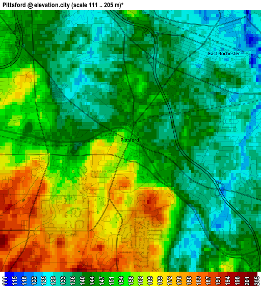
Below is the Elevation map of Pittsford, which displays elevation range with different colors. Scale of the first map is from 111 to 205 m (364 to 673 ft) with average elevation of 148.9 meters (=489 ft) [note 1]
These maps also provides idea of topography and contour of this city, they are displayed at different zoom levels. More info about maps, scale and edge coordinates you can find below images.
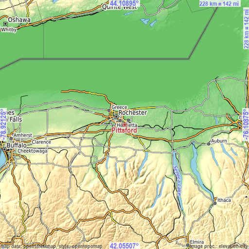
| \ | Map #1 | Topo.Map |
| Scale [m] | 111..205 m | × |
| Scale [ft] | 364..673 ft | × |
| Average | 148.9 m = 489 ft | × |
| Width | 7.14 km = 4.4 mi | 228.4 km = 141.9 mi |
| Height | 7.14 km = 4.4 mi | 228.4 km = 141.9 mi |
| ↑Max Latitude | 43.122704° | 44.10895° |
| Latitude at center | 43.09062° | 43.09062° |
| ↓Min Latitude | 43.058519° | 42.05507° |
| ← Min Longitude | -77.558945° | -78.92125° |
| Longitude center | -77.515° | -77.515° |
| →Max Longitude | -77.471055° | -76.10875° |
Nearby cities:
Cities around Pittsford sort by population:
• Rochester elevation 156 m
10.8 km,  311°
311°
• Irondequoit 117 m
14.6 km,  338°
338°
• Brighton 137 m
7 km, 335°
• Gates-North Gates 170 m
17.2 km,  298°
298°
• Greece 134 m
19.6 km, 312°
• North Gates 163 m
17.9 km, 302°
• East Rochester 138 m
3 km,  48°
48°
• Webster 134 m
15.2 km,  27°
27°
• Fairport 152 m
6 km,  81°
81°
• Victor 180 m
14.8 km,  144°
144°
• Honeoye Falls 203 m
16.6 km,  201°
201°
• Macedon 143 m
17.7 km,  97°
97°
Multilingual:
 En español:
Pittsford elevación 150 m.
 En France:
Pittsford élévation 150 m.
 Auf Deutsch:
Pittsford höhe über dem Meeresspiegel ist 150 m.

Sources and notes:
- [note 1] Map square and city borders are not equal. Map elevation data is calculated only from area inside that square.
- [src 1] Elevation data from geonames database provided with same terms of usage.
- [src 2] The elevation map of Pittsford is generated using elevation data from NASA's 3 arcsec (90m) resolution SRTM data.
- [src 3] Base (background) map © OpenStreetMap contributors tiles are generated by Geofabrik and OpenTopoMap.
Copyright & License:
This Pittsford Elevation Map is licensed under CC BY-SA. You may reuse any part from this page, if you give a proper credit by linking to this URL:
 More info on terms of use page.