Hopewell elevation
Hopewell (New Jersey, Mercer County), United States elevation is 64 meters and Hopewell elevation in feet is 210 ft above sea level [src 1]. Hopewell is a populated place (feature code) with elevation that is 215 meters (705 ft) smaller than average city elevation in United States.
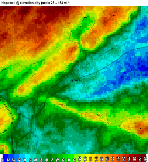
Below is the Elevation map of Hopewell, which displays elevation range with different colors. Scale of the first map is from 27 to 163 m (89 to 535 ft) with average elevation of 87.3 meters (=286 ft) [note 1]
These maps also provides idea of topography and contour of this city, they are displayed at different zoom levels. More info about maps, scale and edge coordinates you can find below images.
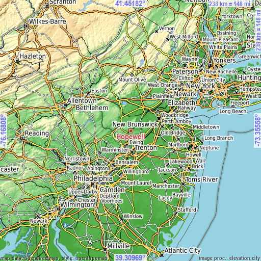
| \ | Map #1 | Topo.Map |
| Scale [m] | 27..163 m | × |
| Scale [ft] | 89..535 ft | × |
| Average | 87.3 m = 286 ft | × |
| Width | 7.44 km = 4.6 mi | 238.2 km = 148 mi |
| Height | 7.44 km = 4.6 mi | 238.2 km = 148 mi |
| ↑Max Latitude | 40.422733° | 41.45182° |
| Latitude at center | 40.38927° | 40.38927° |
| ↓Min Latitude | 40.35579° | 39.30969° |
| ← Min Longitude | -74.805775° | -76.16808° |
| Longitude center | -74.76183° | -74.76183° |
| →Max Longitude | -74.717885° | -73.35558° |
Nearby cities:
Cities around Hopewell sort by population:
• Ewing elevation 56 m
13.7 km,  193°
193°
• Princeton 72 m
9.8 km,  117°
117°
• Bloomingdale 29 m
15.5 km,  38°
38°
• Heathcote 57 m
15.8 km,  90°
90°
• Flemington 56 m
16 km,  328°
328°
• Lawrenceville 43 m
10.6 km,  165°
165°
• Lambertville 28 m
15.6 km,  260°
260°
• Plainsboro Center 26 m
15.5 km,  114°
114°
• Pennington 69 m
7.2 km,  199°
199°
• Princeton Junction 27 m
14.4 km, 123°
• Ten Mile Run 98 m
13.8 km,  78°
78°
• Kingston 37 m
12.7 km,  97°
97°
Multilingual:
 En español:
Hopewell elevación 64 m.
 En France:
Hopewell élévation 64 m.


Sources and notes:
- [note 1] Map square and city borders are not equal. Map elevation data is calculated only from area inside that square.
- [src 1] Elevation data from geonames database provided with same terms of usage.
- [src 2] The elevation map of Hopewell is generated using elevation data from NASA's 3 arcsec (90m) resolution SRTM data.
- [src 3] Base (background) map © OpenStreetMap contributors tiles are generated by Geofabrik and OpenTopoMap.
Copyright & License:
This Hopewell Elevation Map is licensed under CC BY-SA. You may reuse any part from this page, if you give a proper credit by linking to this URL:
 More info on terms of use page.