Keene elevation
Keene (New Hampshire, Cheshire County), United States elevation is 150 meters and Keene elevation in feet is 492 ft above sea level [src 1]. Keene is a seat of a second-order administrative division (feature code) with elevation that is 129 meters (423 ft) smaller than average city elevation in United States.
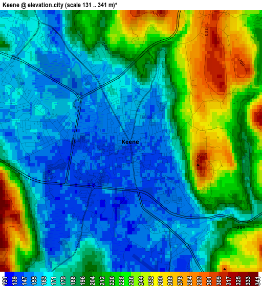
Below is the Elevation map of Keene, which displays elevation range with different colors. Scale of the first map is from 131 to 341 m (430 to 1119 ft) with average elevation of 193.4 meters (=635 ft) [note 1]
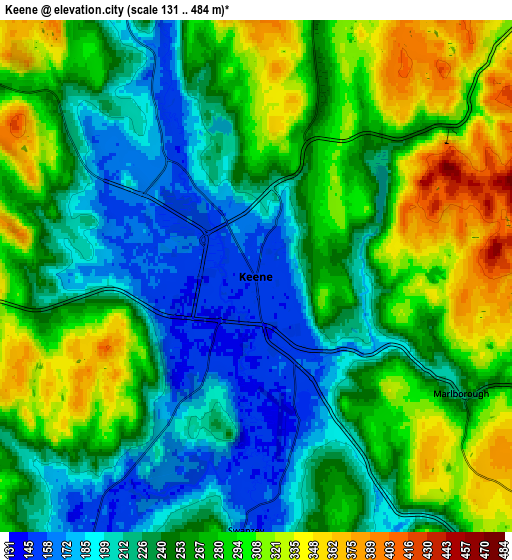
These maps also provides idea of topography and contour of this city, they are displayed at different zoom levels. More info about maps, scale and edge coordinates you can find below images.
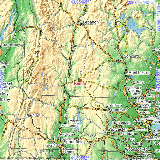
| \ | Map #1 | Map #2 | Topo.Map |
| Scale [m] | 131..341 m | 131..484 m | × |
| Scale [ft] | 430..1119 ft | 430..1588 ft | × |
| Average | 193.4 m = 635 ft | 256.6 m = 842 ft | × |
| Width | 7.15 km = 4.4 mi | 14.31 km = 8.9 mi | 229 km = 142.3 mi |
| Height | 7.15 km = 4.4 mi | 14.31 km = 8.9 mi | 228.9 km = 142.2 mi |
| ↑Max Latitude | 42.965856° | 42.998005° | 43.95465° |
| Latitude at center | 42.93369° | 42.93369° | 42.93369° |
| ↓Min Latitude | 42.901507° | 42.869308° | 41.89552° |
| ← Min Longitude | -72.322085° | -72.366031° | -73.68439° |
| Longitude center | -72.27814° | -72.27814° | -72.27814° |
| →Max Longitude | -72.234195° | -72.190249° | -70.87189° |
Nearby cities:
Cities around Keene sort by population:
• Swanzey elevation 158 m
7.1 km,  182°
182°
• Chesterfield 259 m
16.5 km,  251°
251°
• Fitzwilliam 351 m
20.3 km,  146°
146°
• Westmoreland 129 m
13.7 km,  283°
283°
• Winchester 135 m
19.8 km,  205°
205°
• Dublin 462 m
17.8 km,  99°
99°
• Hinsdale 70 m
23.6 km,  225°
225°
• West Swanzey 162 m
7.9 km, 206°
• Troy 311 m
14.5 km, 147°
• Richmond 327 m
19.9 km, 178°
• Harrisville 416 m
14.8 km,  85°
85°
• Marlborough 222 m
6.6 km,  119°
119°
Multilingual:
 En español:
Keene elevación 150 m.
 En France:
Keene élévation 150 m.


Sources and notes:
- [note 1] Map square and city borders are not equal. Map elevation data is calculated only from area inside that square.
- [src 1] Elevation data from geonames database provided with same terms of usage.
- [src 2] The elevation map of Keene is generated using elevation data from NASA's 3 arcsec (90m) resolution SRTM data.
- [src 3] Base (background) map © OpenStreetMap contributors tiles are generated by Geofabrik and OpenTopoMap.
Copyright & License:
This Keene Elevation Map is licensed under CC BY-SA. You may reuse any part from this page, if you give a proper credit by linking to this URL:
 More info on terms of use page.