Winchester elevation
Winchester (New Hampshire, Cheshire County), United States elevation is 135 meters and Winchester elevation in feet is 443 ft above sea level [src 1]. Winchester is a populated place (feature code) with elevation that is 144 meters (472 ft) smaller than average city elevation in United States.
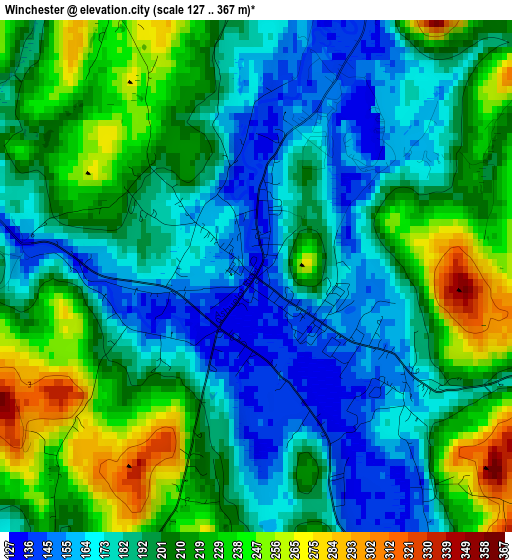
Below is the Elevation map of Winchester, which displays elevation range with different colors. Scale of the first map is from 127 to 367 m (417 to 1204 ft) with average elevation of 199.4 meters (=654 ft) [note 1]
These maps also provides idea of topography and contour of this city, they are displayed at different zoom levels. More info about maps, scale and edge coordinates you can find below images.
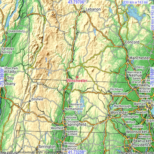
| \ | Map #1 | Topo.Map |
| Scale [m] | 127..367 m | × |
| Scale [ft] | 417..1204 ft | × |
| Average | 199.4 m = 654 ft | × |
| Width | 7.17 km = 4.5 mi | 229.5 km = 142.6 mi |
| Height | 7.17 km = 4.5 mi | 229.5 km = 142.6 mi |
| ↑Max Latitude | 42.805669° | 43.79706° |
| Latitude at center | 42.77342° | 42.77342° |
| ↓Min Latitude | 42.741154° | 41.73258° |
| ← Min Longitude | -72.427085° | -73.78939° |
| Longitude center | -72.38314° | -72.38314° |
| →Max Longitude | -72.339195° | -70.97689° |
Nearby cities:
Cities around Winchester sort by population:
• Brattleboro elevation 79 m
16.7 km,  301°
301°
• Swanzey 158 m
13.5 km,  37°
37°
• Chesterfield 259 m
14.5 km,  330°
330°
• Bernardston 115 m
17.7 km,  230°
230°
• Hinsdale 70 m
8.6 km,  279°
279°
• Erving 150 m
19.3 km,  183°
183°
• Gill 82 m
17.6 km,  212°
212°
• West Swanzey 162 m
11.9 km,  24°
24°
• Royalston 309 m
19.2 km,  123°
123°
• Troy 311 m
17.4 km,  71°
71°
• Richmond 327 m
9.3 km,  102°
102°
• Northfield 91 m
10.3 km, 213°
Multilingual:
 En español:
Winchester elevación 135 m.
 En France:
Winchester élévation 135 m.
 Auf Deutsch:
Winchester höhe über dem Meeresspiegel ist 135 m.

Sources and notes:
- [note 1] Map square and city borders are not equal. Map elevation data is calculated only from area inside that square.
- [src 1] Elevation data from geonames database provided with same terms of usage.
- [src 2] The elevation map of Winchester is generated using elevation data from NASA's 3 arcsec (90m) resolution SRTM data.
- [src 3] Base (background) map © OpenStreetMap contributors tiles are generated by Geofabrik and OpenTopoMap.
Copyright & License:
This Winchester Elevation Map is licensed under CC BY-SA. You may reuse any part from this page, if you give a proper credit by linking to this URL:
 More info on terms of use page.