Harrisville elevation
Harrisville (New Hampshire, Cheshire County), United States elevation is 416 meters and Harrisville elevation in feet is 1365 ft above sea level [src 1]. Harrisville is a populated place (feature code) with elevation that is 137 meters (449 ft) bigger than average city elevation in United States.
Below is the Elevation map of Harrisville, which displays elevation range with different colors. Scale of the first map is from 328 to 583 m (1076 to 1913 ft) with average elevation of 435.1 meters (=1427 ft) [note 1]
These maps also provides idea of topography and contour of this city, they are displayed at different zoom levels. More info about maps, scale and edge coordinates you can find below images.
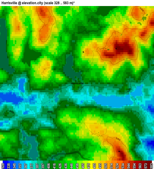
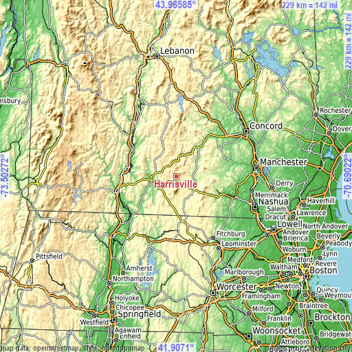
| \ | Map #1 | Topo.Map |
| Scale [m] | 328..583 m | × |
| Scale [ft] | 1076..1913 ft | × |
| Average | 435.1 m = 1427 ft | × |
| Width | 7.15 km = 4.4 mi | 228.9 km = 142.2 mi |
| Height | 7.15 km = 4.4 mi | 228.9 km = 142.2 mi |
| ↑Max Latitude | 42.97724° | 43.96585° |
| Latitude at center | 42.94508° | 42.94508° |
| ↓Min Latitude | 42.912903° | 41.9071° |
| ← Min Longitude | -72.140415° | -73.50272° |
| Longitude center | -72.09647° | -72.09647° |
| →Max Longitude | -72.052525° | -70.69022° |
Nearby cities:
Cities around Harrisville sort by population:
• Keene elevation 150 m
14.8 km,  265°
265°
• Swanzey 158 m
17.3 km,  240°
240°
• Rindge 403 m
22.7 km,  161°
161°
• Peterborough 227 m
14.4 km,  125°
125°
• Jaffrey 311 m
15.8 km, 157°
• Fitzwilliam 351 m
18.7 km,  191°
191°
• Greenfield 262 m
18.3 km,  88°
88°
• Dublin 462 m
5 km,  146°
146°
• Antrim 218 m
16 km,  53°
53°
• West Swanzey 162 m
20.2 km,  245°
245°
• Troy 311 m
15.1 km,  207°
207°
• Marlborough 222 m
10.1 km, 243°
Multilingual:
 En español:
Harrisville elevación 416 m.
 En France:
Harrisville élévation 416 m.
 Auf Deutsch:
Harrisville höhe über dem Meeresspiegel ist 416 m.

Sources and notes:
- [note 1] Map square and city borders are not equal. Map elevation data is calculated only from area inside that square.
- [src 1] Elevation data from geonames database provided with same terms of usage.
- [src 2] The elevation map of Harrisville is generated using elevation data from NASA's 3 arcsec (90m) resolution SRTM data.
- [src 3] Base (background) map © OpenStreetMap contributors tiles are generated by Geofabrik and OpenTopoMap.
Copyright & License:
This Harrisville Elevation Map is licensed under CC BY-SA. You may reuse any part from this page, if you give a proper credit by linking to this URL:
 More info on terms of use page.