Rindge elevation
Rindge (New Hampshire, Cheshire County), United States elevation is 403 meters and Rindge elevation in feet is 1322 ft above sea level [src 1]. Rindge is a populated place (feature code) with elevation that is 124 meters (407 ft) bigger than average city elevation in United States.
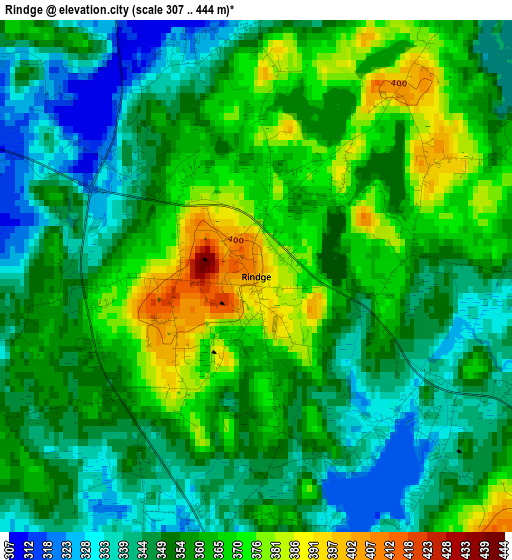
Below is the Elevation map of Rindge, which displays elevation range with different colors. Scale of the first map is from 307 to 444 m (1007 to 1457 ft) with average elevation of 355.9 meters (=1168 ft) [note 1]
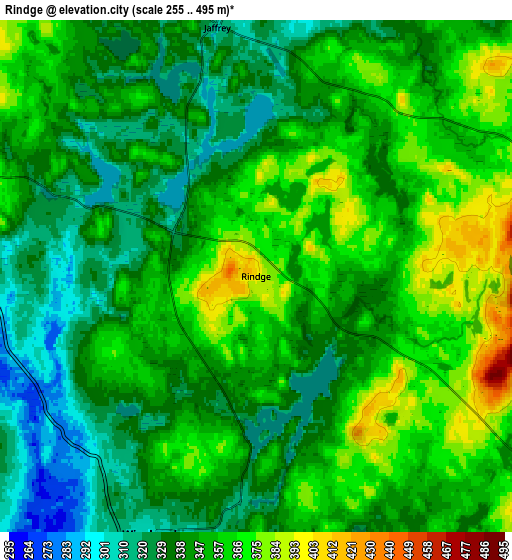
These maps also provides idea of topography and contour of this city, they are displayed at different zoom levels. More info about maps, scale and edge coordinates you can find below images.
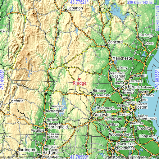
| \ | Map #1 | Map #2 | Topo.Map |
| Scale [m] | 307..444 m | 255..495 m | × |
| Scale [ft] | 1007..1457 ft | 837..1624 ft | × |
| Average | 355.9 m = 1168 ft | 347.5 m = 1140 ft | × |
| Width | 7.18 km = 4.5 mi | 14.35 km = 8.9 mi | 229.6 km = 142.7 mi |
| Height | 7.18 km = 4.5 mi | 14.35 km = 8.9 mi | 229.6 km = 142.7 mi |
| ↑Max Latitude | 42.783461° | 42.815705° | 43.77521° |
| Latitude at center | 42.7512° | 42.7512° | 42.7512° |
| ↓Min Latitude | 42.718922° | 42.686628° | 41.70999° |
| ← Min Longitude | -72.053745° | -72.097691° | -73.41605° |
| Longitude center | -72.0098° | -72.0098° | -72.0098° |
| →Max Longitude | -71.965855° | -71.921909° | -70.60355° |
Nearby cities:
Cities around Rindge sort by population:
• Ashburnham elevation 306 m
15.3 km,  146°
146°
• New Ipswich 326 m
12.7 km,  91°
91°
• Winchendon 302 m
7.7 km,  201°
201°
• Peterborough 227 m
14.1 km,  19°
19°
• Jaffrey 311 m
7.1 km,  351°
351°
• Fitzwilliam 351 m
11.3 km,  286°
286°
• Baldwinville 273 m
16.8 km, 198°
• Temple 313 m
14.9 km,  60°
60°
• Royalston 309 m
16.7 km,  240°
240°
• Troy 311 m
16.2 km,  300°
300°
• Greenville 255 m
16.2 km,  83°
83°
• South Ashburnham 301 m
16.7 km,  159°
159°
Multilingual:
 En español:
Rindge elevación 403 m.
 En France:
Rindge élévation 403 m.


Sources and notes:
- [note 1] Map square and city borders are not equal. Map elevation data is calculated only from area inside that square.
- [src 1] Elevation data from geonames database provided with same terms of usage.
- [src 2] The elevation map of Rindge is generated using elevation data from NASA's 3 arcsec (90m) resolution SRTM data.
- [src 3] Base (background) map © OpenStreetMap contributors tiles are generated by Geofabrik and OpenTopoMap.
Copyright & License:
This Rindge Elevation Map is licensed under CC BY-SA. You may reuse any part from this page, if you give a proper credit by linking to this URL:
 More info on terms of use page.