Ashburnham elevation
Ashburnham (Massachusetts, Worcester County), United States elevation is 306 meters and Ashburnham elevation in feet is 1004 ft above sea level [src 1]. Ashburnham is a populated place (feature code) with elevation that is 27 meters (89 ft) bigger than average city elevation in United States.
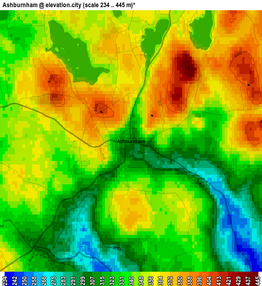
Below is the Elevation map of Ashburnham, which displays elevation range with different colors. Scale of the first map is from 234 to 445 m (768 to 1460 ft) with average elevation of 342.6 meters (=1124 ft) [note 1]
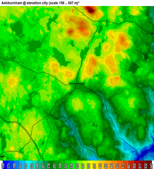
These maps also provides idea of topography and contour of this city, they are displayed at different zoom levels. More info about maps, scale and edge coordinates you can find below images.
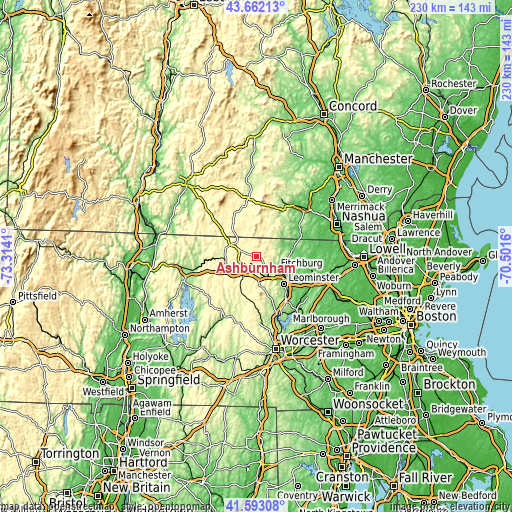
| \ | Map #1 | Map #2 | Topo.Map |
| Scale [m] | 234..445 m | 156..547 m | × |
| Scale [ft] | 768..1460 ft | 512..1795 ft | × |
| Average | 342.6 m = 1124 ft | 333.3 m = 1094 ft | × |
| Width | 7.19 km = 4.5 mi | 14.38 km = 8.9 mi | 230.1 km = 143 mi |
| Height | 7.19 km = 4.5 mi | 14.38 km = 8.9 mi | 230 km = 142.9 mi |
| ↑Max Latitude | 42.668521° | 42.700825° | 43.66213° |
| Latitude at center | 42.6362° | 42.6362° | 42.6362° |
| ↓Min Latitude | 42.603862° | 42.571508° | 41.59308° |
| ← Min Longitude | -71.951795° | -71.995741° | -73.3141° |
| Longitude center | -71.90785° | -71.90785° | -71.90785° |
| →Max Longitude | -71.863905° | -71.819959° | -70.5016° |
Nearby cities:
Cities around Ashburnham sort by population:
• Fitchburg elevation 144 m
10.4 km,  124°
124°
• Gardner 325 m
10 km,  227°
227°
• Westminster 328 m
10 km,  181°
181°
• Templeton 349 m
15.8 km,  235°
235°
• Rindge 403 m
15.3 km,  326°
326°
• New Ipswich 326 m
13.2 km,  19°
19°
• Winchendon 302 m
12.4 km,  296°
296°
• Ashby 278 m
8.5 km,  57°
57°
• Baldwinville 273 m
14.1 km,  257°
257°
• Lunenburg 177 m
15.7 km,  107°
107°
• Greenville 255 m
16.5 km,  28°
28°
• South Ashburnham 301 m
3.8 km,  221°
221°
Multilingual:
 En español:
Ashburnham elevación 306 m.
 En France:
Ashburnham élévation 306 m.
 Auf Deutsch:
Ashburnham höhe über dem Meeresspiegel ist 306 m.

Sources and notes:
- [note 1] Map square and city borders are not equal. Map elevation data is calculated only from area inside that square.
- [src 1] Elevation data from geonames database provided with same terms of usage.
- [src 2] The elevation map of Ashburnham is generated using elevation data from NASA's 3 arcsec (90m) resolution SRTM data.
- [src 3] Base (background) map © OpenStreetMap contributors tiles are generated by Geofabrik and OpenTopoMap.
Copyright & License:
This Ashburnham Elevation Map is licensed under CC BY-SA. You may reuse any part from this page, if you give a proper credit by linking to this URL:
 More info on terms of use page.