Lunenburg elevation
Lunenburg (Massachusetts, Worcester County), United States elevation is 177 meters and Lunenburg elevation in feet is 581 ft above sea level [src 1]. Lunenburg is a populated place (feature code) with elevation that is 102 meters (335 ft) smaller than average city elevation in United States.
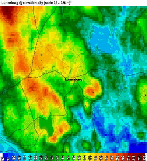
Below is the Elevation map of Lunenburg, which displays elevation range with different colors. Scale of the first map is from 92 to 228 m (302 to 748 ft) with average elevation of 146.9 meters (=482 ft) [note 1]
These maps also provides idea of topography and contour of this city, they are displayed at different zoom levels. More info about maps, scale and edge coordinates you can find below images.
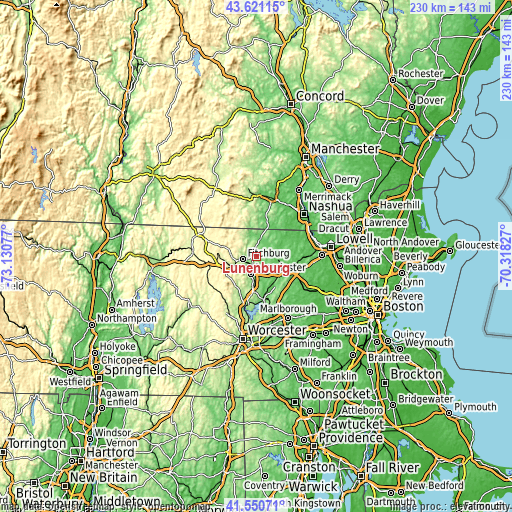
| \ | Map #1 | Topo.Map |
| Scale [m] | 92..228 m | × |
| Scale [ft] | 302..748 ft | × |
| Average | 146.9 m = 482 ft | × |
| Width | 7.19 km = 4.5 mi | 230.2 km = 143 mi |
| Height | 7.19 km = 4.5 mi | 230.2 km = 143 mi |
| ↑Max Latitude | 42.626872° | 43.62115° |
| Latitude at center | 42.59453° | 42.59453° |
| ↓Min Latitude | 42.562171° | 41.55071° |
| ← Min Longitude | -71.768465° | -73.13077° |
| Longitude center | -71.72452° | -71.72452° |
| →Max Longitude | -71.680575° | -70.31827° |
Nearby cities:
Cities around Lunenburg sort by population:
• Leominster elevation 124 m
8.2 km,  200°
200°
• Fitchburg 144 m
6.5 km,  259°
259°
• Harvard 129 m
15.7 km,  132°
132°
• Ashburnham 306 m
15.7 km,  287°
287°
• Ashby 278 m
12.1 km,  319°
319°
• Ayer 75 m
11.6 km,  108°
108°
• Pepperell 78 m
13.7 km,  54°
54°
• East Pepperell 74 m
14.7 km,  57°
57°
• Devens 90 m
10.7 km,  121°
121°
• Shirley 89 m
8.3 km, 132°
• Townsend 97 m
8.2 km,  11°
11°
• Groton 105 m
12.4 km,  81°
81°
Multilingual:
 En español:
Lunenburg elevación 177 m.
 En France:
Lunenburg élévation 177 m.
 Auf Deutsch:
Lunenburg höhe über dem Meeresspiegel ist 177 m.

Sources and notes:
- [note 1] Map square and city borders are not equal. Map elevation data is calculated only from area inside that square.
- [src 1] Elevation data from geonames database provided with same terms of usage.
- [src 2] The elevation map of Lunenburg is generated using elevation data from NASA's 3 arcsec (90m) resolution SRTM data.
- [src 3] Base (background) map © OpenStreetMap contributors tiles are generated by Geofabrik and OpenTopoMap.
Copyright & License:
This Lunenburg Elevation Map is licensed under CC BY-SA. You may reuse any part from this page, if you give a proper credit by linking to this URL:
 More info on terms of use page.