Pawnee City elevation
Pawnee City (Nebraska, Pawnee County), United States elevation is 368 meters and Pawnee City elevation in feet is 1207 ft above sea level [src 1]. Pawnee City is a seat of a second-order administrative division (feature code) with elevation that is 89 meters (292 ft) bigger than average city elevation in United States.
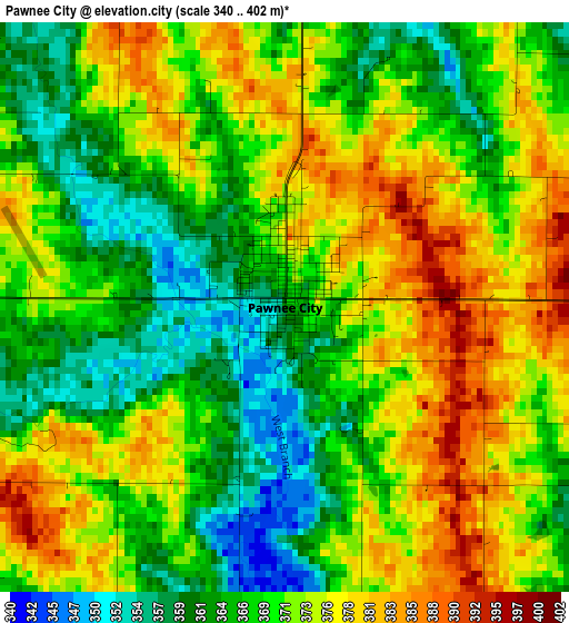
Below is the Elevation map of Pawnee City, which displays elevation range with different colors. Scale of the first map is from 340 to 402 m (1115 to 1319 ft) with average elevation of 370.4 meters (=1215 ft) [note 1]
These maps also provides idea of topography and contour of this city, they are displayed at different zoom levels. More info about maps, scale and edge coordinates you can find below images.
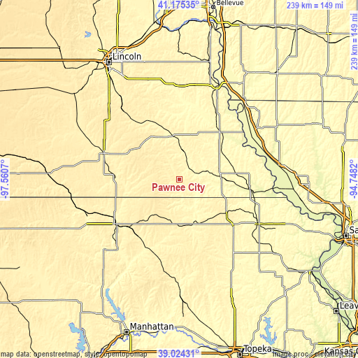
| \ | Map #1 | Topo.Map |
| Scale [m] | 340..402 m | × |
| Scale [ft] | 1115..1319 ft | × |
| Average | 370.4 m = 1215 ft | × |
| Width | 7.47 km = 4.6 mi | 239.2 km = 148.6 mi |
| Height | 7.47 km = 4.6 mi | 239.2 km = 148.6 mi |
| ↑Max Latitude | 40.141932° | 41.17535° |
| Latitude at center | 40.10833° | 40.10833° |
| ↓Min Latitude | 40.074711° | 39.02431° |
| ← Min Longitude | -96.198395° | -97.5607° |
| Longitude center | -96.15445° | -96.15445° |
| →Max Longitude | -96.110505° | -94.7482° |
Nearby cities:
Cities around Pawnee City sort by population:
• Beatrice elevation 395 m
53.4 km,  289°
289°
• Nebraska City 322 m
68 km,  21°
21°
• Falls City 309 m
47.3 km,  96°
96°
• Auburn 302 m
41.4 km,  40°
40°
• Marysville 355 m
51.4 km,  234°
234°
• Hiawatha 351 m
59.9 km,  118°
118°
• Sabetha 403 m
37.8 km,  127°
127°
• Seneca 350 m
31.4 km,  165°
165°
• Syracuse 320 m
61.1 km,  357°
357°
• Tecumseh 346 m
28.9 km,  352°
352°
• Wymore 377 m
43.2 km,  272°
272°
• Rock Port 287 m
63.7 km,  58°
58°
Multilingual:
 En español:
Pawnee City elevación 368 m.
 En France:
Pawnee City élévation 368 m.
 Auf Deutsch:
Pawnee City höhe über dem Meeresspiegel ist 368 m.

Sources and notes:
- [note 1] Map square and city borders are not equal. Map elevation data is calculated only from area inside that square.
- [src 1] Elevation data from geonames database provided with same terms of usage.
- [src 2] The elevation map of Pawnee City is generated using elevation data from NASA's 3 arcsec (90m) resolution SRTM data.
- [src 3] Base (background) map © OpenStreetMap contributors tiles are generated by Geofabrik and OpenTopoMap.
Copyright & License:
This Pawnee City Elevation Map is licensed under CC BY-SA. You may reuse any part from this page, if you give a proper credit by linking to this URL:
 More info on terms of use page.