Wymore elevation
Wymore (Nebraska, Gage County), United States elevation is 377 meters and Wymore elevation in feet is 1237 ft above sea level [src 1]. Wymore is a populated place (feature code) with elevation that is 98 meters (322 ft) bigger than average city elevation in United States.
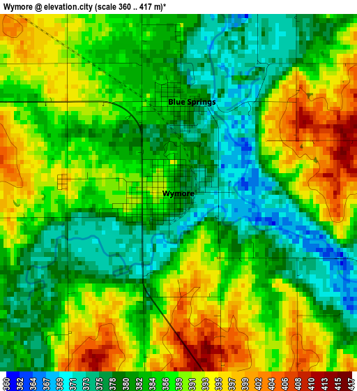
Below is the Elevation map of Wymore, which displays elevation range with different colors. Scale of the first map is from 360 to 417 m (1181 to 1368 ft) with average elevation of 385.8 meters (=1266 ft) [note 1]
These maps also provides idea of topography and contour of this city, they are displayed at different zoom levels. More info about maps, scale and edge coordinates you can find below images.
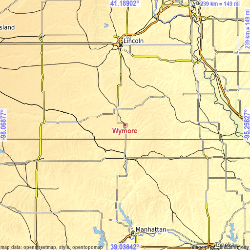
| \ | Map #1 | Topo.Map |
| Scale [m] | 360..417 m | × |
| Scale [ft] | 1181..1368 ft | × |
| Average | 385.8 m = 1266 ft | × |
| Width | 7.47 km = 4.6 mi | 239.1 km = 148.6 mi |
| Height | 7.47 km = 4.6 mi | 239.1 km = 148.6 mi |
| ↑Max Latitude | 40.155815° | 41.18902° |
| Latitude at center | 40.12222° | 40.12222° |
| ↓Min Latitude | 40.088608° | 39.03842° |
| ← Min Longitude | -96.706465° | -98.06877° |
| Longitude center | -96.66252° | -96.66252° |
| →Max Longitude | -96.618575° | -95.25627° |
Nearby cities:
Cities around Wymore sort by population:
• Lincoln elevation 366 m
75.4 km,  359°
359°
• Beatrice 395 m
17.7 km,  336°
336°
• Crete 415 m
61.7 km, 335°
• Fairbury 407 m
44.1 km,  272°
272°
• Marysville 355 m
31.3 km,  177°
177°
• Hickman 391 m
55.4 km,  2°
2°
• Seneca 350 m
60.2 km,  122°
122°
• Syracuse 320 m
71.9 km,  34°
34°
• Wilber 406 m
47.3 km,  327°
327°
• Tecumseh 346 m
48 km,  55°
55°
• Washington 407 m
47.3 km,  224°
224°
• Pawnee City 368 m
43.2 km,  92°
92°
Multilingual:
 En español:
Wymore elevación 377 m.
 En France:
Wymore élévation 377 m.


Sources and notes:
- [note 1] Map square and city borders are not equal. Map elevation data is calculated only from area inside that square.
- [src 1] Elevation data from geonames database provided with same terms of usage.
- [src 2] The elevation map of Wymore is generated using elevation data from NASA's 3 arcsec (90m) resolution SRTM data.
- [src 3] Base (background) map © OpenStreetMap contributors tiles are generated by Geofabrik and OpenTopoMap.
Copyright & License:
This Wymore Elevation Map is licensed under CC BY-SA. You may reuse any part from this page, if you give a proper credit by linking to this URL:
 More info on terms of use page.