Wabasha elevation
Wabasha (Minnesota, Wabasha County), United States elevation is 211 meters and Wabasha elevation in feet is 692 ft above sea level [src 1]. Wabasha is a seat of a second-order administrative division (feature code) with elevation that is 68 meters (223 ft) smaller than average city elevation in United States.
Below is the Elevation map of Wabasha, which displays elevation range with different colors. Scale of the first map is from 197 to 369 m (646 to 1211 ft) with average elevation of 227.5 meters (=746 ft) [note 1]
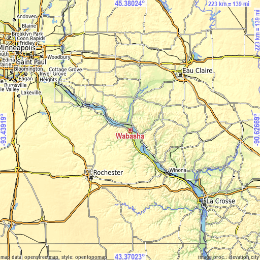
These maps also provides idea of topography and contour of this city, they are displayed at different zoom levels. More info about maps, scale and edge coordinates you can find below images.
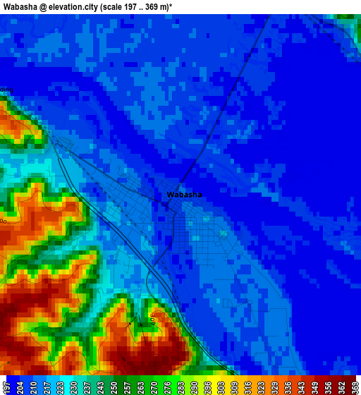
| \ | Map #1 | Topo.Map |
| Scale [m] | 197..369 m | × |
| Scale [ft] | 646..1211 ft | × |
| Average | 227.5 m = 746 ft | × |
| Width | 6.98 km = 4.3 mi | 223.5 km = 138.9 mi |
| Height | 6.98 km = 4.3 mi | 223.5 km = 138.9 mi |
| ↑Max Latitude | 44.415258° | 45.38024° |
| Latitude at center | 44.38386° | 44.38386° |
| ↓Min Latitude | 44.352445° | 43.37023° |
| ← Min Longitude | -92.076885° | -93.43919° |
| Longitude center | -92.03294° | -92.03294° |
| →Max Longitude | -91.988995° | -90.62669° |
Nearby cities:
Cities around Wabasha sort by population:
• Red Wing elevation 223 m
44.4 km,  296°
296°
• Lake City 212 m
20.1 km,  291°
291°
• Goodview 205 m
44.7 km,  143°
143°
• Saint Charles 345 m
46.2 km,  183°
183°
• Plainview 355 m
26.7 km,  204°
204°
• Arcadia 221 m
44.7 km,  109°
109°
• Mondovi 247 m
35.3 km,  54°
54°
• Eyota 377 m
46.7 km, 199°
• Durand 224 m
27.5 km,  11°
11°
• Lewiston 369 m
46.3 km,  163°
163°
• Elgin 326 m
33.1 km,  211°
211°
• Alma 207 m
11.8 km,  127°
127°
Multilingual:
 En español:
Wabasha elevación 211 m.
 En France:
Wabasha élévation 211 m.


Sources and notes:
- [note 1] Map square and city borders are not equal. Map elevation data is calculated only from area inside that square.
- [src 1] Elevation data from geonames database provided with same terms of usage.
- [src 2] The elevation map of Wabasha is generated using elevation data from NASA's 3 arcsec (90m) resolution SRTM data.
- [src 3] Base (background) map © OpenStreetMap contributors tiles are generated by Geofabrik and OpenTopoMap.
Copyright & License:
This Wabasha Elevation Map is licensed under CC BY-SA. You may reuse any part from this page, if you give a proper credit by linking to this URL:
 More info on terms of use page.