Elgin elevation
Elgin (Minnesota, Wabasha County), United States elevation is 326 meters and Elgin elevation in feet is 1070 ft above sea level [src 1]. Elgin is a populated place (feature code) with elevation that is 47 meters (154 ft) bigger than average city elevation in United States.
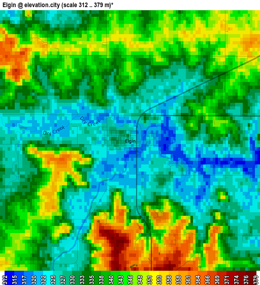
Below is the Elevation map of Elgin, which displays elevation range with different colors. Scale of the first map is from 312 to 379 m (1024 to 1243 ft) with average elevation of 336.6 meters (=1104 ft) [note 1]
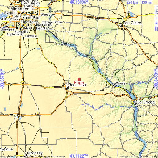
These maps also provides idea of topography and contour of this city, they are displayed at different zoom levels. More info about maps, scale and edge coordinates you can find below images.
| \ | Map #1 | Topo.Map |
| Scale [m] | 312..379 m | × |
| Scale [ft] | 1024..1243 ft | × |
| Average | 336.6 m = 1104 ft | × |
| Width | 7.01 km = 4.4 mi | 224.5 km = 139.5 mi |
| Height | 7.01 km = 4.4 mi | 224.4 km = 139.4 mi |
| ↑Max Latitude | 44.161774° | 45.13096° |
| Latitude at center | 44.13024° | 44.13024° |
| ↓Min Latitude | 44.098689° | 43.11227° |
| ← Min Longitude | -92.295505° | -93.65781° |
| Longitude center | -92.25156° | -92.25156° |
| →Max Longitude | -92.207615° | -90.84531° |
Nearby cities:
Cities around Elgin sort by population:
• Rochester elevation 314 m
21.2 km,  235°
235°
• Byron 384 m
33.3 km,  250°
250°
• Lake City 212 m
35.5 km,  357°
357°
• Saint Charles 345 m
23.3 km,  140°
140°
• Pine Island 307 m
32.5 km,  284°
284°
• Plainview 355 m
7.5 km,  58°
58°
• Chatfield 308 m
32.1 km,  171°
171°
• Wabasha 211 m
33.1 km,  31°
31°
• Eyota 377 m
15.9 km, 173°
• Lewiston 369 m
34.6 km,  117°
117°
• Oronoco 296 m
23 km, 279°
• Alma 207 m
34.1 km,  51°
51°
Multilingual:
 En español:
Elgin elevación 326 m.
 En France:
Elgin élévation 326 m.


Sources and notes:
- [note 1] Map square and city borders are not equal. Map elevation data is calculated only from area inside that square.
- [src 1] Elevation data from geonames database provided with same terms of usage.
- [src 2] The elevation map of Elgin is generated using elevation data from NASA's 3 arcsec (90m) resolution SRTM data.
- [src 3] Base (background) map © OpenStreetMap contributors tiles are generated by Geofabrik and OpenTopoMap.
Copyright & License:
This Elgin Elevation Map is licensed under CC BY-SA. You may reuse any part from this page, if you give a proper credit by linking to this URL:
 More info on terms of use page.