Red Wing elevation
Red Wing (Minnesota, Goodhue County), United States elevation is 223 meters and Red Wing elevation in feet is 732 ft above sea level [src 1]. Red Wing is a seat of a second-order administrative division (feature code) with elevation that is 56 meters (184 ft) smaller than average city elevation in United States.
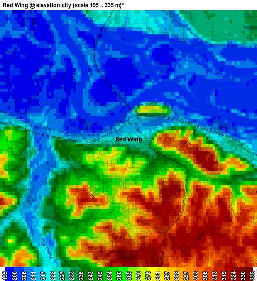
Below is the Elevation map of Red Wing, which displays elevation range with different colors. Scale of the first map is from 195 to 335 m (640 to 1099 ft) with average elevation of 241.2 meters (=791 ft) [note 1]
These maps also provides idea of topography and contour of this city, they are displayed at different zoom levels. More info about maps, scale and edge coordinates you can find below images.
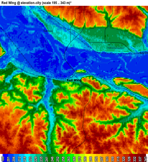
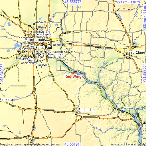
| \ | Map #1 | Map #2 | Topo.Map |
| Scale [m] | 195..335 m | 195..343 m | × |
| Scale [ft] | 640..1099 ft | 640..1125 ft | × |
| Average | 241.2 m = 791 ft | 258.8 m = 849 ft | × |
| Width | 6.96 km = 4.3 mi | 13.93 km = 8.7 mi | 222.8 km = 138.4 mi |
| Height | 6.96 km = 4.3 mi | 13.93 km = 8.7 mi | 222.8 km = 138.4 mi |
| ↑Max Latitude | 44.593772° | 44.625057° | 45.55577° |
| Latitude at center | 44.56247° | 44.56247° | 44.56247° |
| ↓Min Latitude | 44.531151° | 44.499815° | 43.55191° |
| ← Min Longitude | -92.577745° | -92.621691° | -93.94005° |
| Longitude center | -92.5338° | -92.5338° | -92.5338° |
| →Max Longitude | -92.489855° | -92.445909° | -91.12755° |
Nearby cities:
Cities around Red Wing sort by population:
• Hastings elevation 218 m
32.2 km,  308°
308°
• River Falls 270 m
34 km,  347°
347°
• Lake City 212 m
24.5 km,  120°
120°
• Prescott 213 m
29.7 km, 314°
• Cannon Falls 251 m
30.1 km,  258°
258°
• Zumbrota 299 m
31.7 km,  199°
199°
• Pine Island 307 m
41.1 km,  192°
192°
• Ellsworth 370 m
19.2 km,  11°
11°
• Afton 215 m
42.7 km,  332°
332°
• Spring Valley 280 m
39.1 km,  36°
36°
• Goodhue 340 m
19.4 km, 201°
• Wanamingo 319 m
35.2 km,  215°
215°
Multilingual:
 En español:
Red Wing elevación 223 m.
 En France:
Red Wing élévation 223 m.
 Auf Deutsch:
Red Wing höhe über dem Meeresspiegel ist 223 m.

Sources and notes:
- [note 1] Map square and city borders are not equal. Map elevation data is calculated only from area inside that square.
- [src 1] Elevation data from geonames database provided with same terms of usage.
- [src 2] The elevation map of Red Wing is generated using elevation data from NASA's 3 arcsec (90m) resolution SRTM data.
- [src 3] Base (background) map © OpenStreetMap contributors tiles are generated by Geofabrik and OpenTopoMap.
Copyright & License:
This Red Wing Elevation Map is licensed under CC BY-SA. You may reuse any part from this page, if you give a proper credit by linking to this URL:
 More info on terms of use page.