Durand elevation
Durand (Wisconsin, Pepin County), United States elevation is 224 meters and Durand elevation in feet is 735 ft above sea level [src 1]. Durand is a seat of a second-order administrative division (feature code) with elevation that is 55 meters (180 ft) smaller than average city elevation in United States.
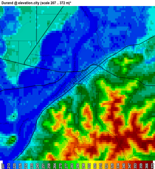
Below is the Elevation map of Durand, which displays elevation range with different colors. Scale of the first map is from 207 to 372 m (679 to 1220 ft) with average elevation of 252.1 meters (=827 ft) [note 1]
These maps also provides idea of topography and contour of this city, they are displayed at different zoom levels. More info about maps, scale and edge coordinates you can find below images.
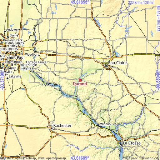
| \ | Map #1 | Topo.Map |
| Scale [m] | 207..372 m | × |
| Scale [ft] | 679..1220 ft | × |
| Average | 252.1 m = 827 ft | × |
| Width | 6.96 km = 4.3 mi | 222.6 km = 138.3 mi |
| Height | 6.96 km = 4.3 mi | 222.6 km = 138.3 mi |
| ↑Max Latitude | 44.657618° | 45.61855° |
| Latitude at center | 44.62635° | 44.62635° |
| ↓Min Latitude | 44.595066° | 43.61689° |
| ← Min Longitude | -92.009675° | -93.37198° |
| Longitude center | -91.96573° | -91.96573° |
| →Max Longitude | -91.921785° | -90.55948° |
Nearby cities:
Cities around Durand sort by population:
• Eau Claire elevation 244 m
42.3 km,  60°
60°
• Red Wing 223 m
45.5 km,  261°
261°
• Menomonie 269 m
27.9 km,  7°
7°
• Lake City 212 m
31 km,  230°
230°
• Ellsworth 370 m
42.9 km,  285°
285°
• Mondovi 247 m
24.2 km,  105°
105°
• Wabasha 211 m
27.5 km,  191°
191°
• Tainter Lake 268 m
41.4 km, 13°
• Spring Valley 280 m
32.5 km,  318°
318°
• Woodville 346 m
44.5 km, 324°
• Colfax 288 m
45.4 km,  24°
24°
• Alma 207 m
34.3 km,  173°
173°
Multilingual:
 En español:
Durand elevación 224 m.
 En France:
Durand élévation 224 m.


Sources and notes:
- [note 1] Map square and city borders are not equal. Map elevation data is calculated only from area inside that square.
- [src 1] Elevation data from geonames database provided with same terms of usage.
- [src 2] The elevation map of Durand is generated using elevation data from NASA's 3 arcsec (90m) resolution SRTM data.
- [src 3] Base (background) map © OpenStreetMap contributors tiles are generated by Geofabrik and OpenTopoMap.
Copyright & License:
This Durand Elevation Map is licensed under CC BY-SA. You may reuse any part from this page, if you give a proper credit by linking to this URL:
 More info on terms of use page.