Tracy elevation
Tracy (Minnesota, Lyon County), United States elevation is 426 meters and Tracy elevation in feet is 1398 ft above sea level [src 1]. Tracy is a populated place (feature code) with elevation that is 147 meters (482 ft) bigger than average city elevation in United States.
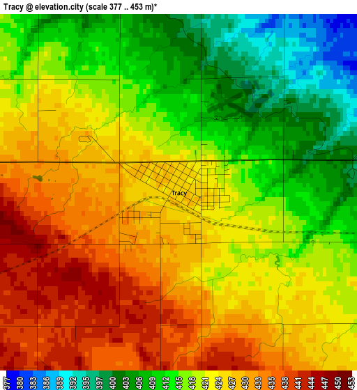
Below is the Elevation map of Tracy, which displays elevation range with different colors. Scale of the first map is from 377 to 453 m (1237 to 1486 ft) with average elevation of 420.8 meters (=1381 ft) [note 1]
These maps also provides idea of topography and contour of this city, they are displayed at different zoom levels. More info about maps, scale and edge coordinates you can find below images.
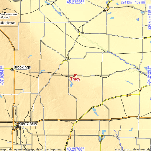
| \ | Map #1 | Topo.Map |
| Scale [m] | 377..453 m | × |
| Scale [ft] | 1237..1486 ft | × |
| Average | 420.8 m = 1381 ft | × |
| Width | 7 km = 4.3 mi | 224.1 km = 139.2 mi |
| Height | 7 km = 4.3 mi | 224.1 km = 139.2 mi |
| ↑Max Latitude | 44.264769° | 45.23225° |
| Latitude at center | 44.23329° | 44.23329° |
| ↓Min Latitude | 44.201795° | 43.21708° |
| ← Min Longitude | -95.663125° | -97.02543° |
| Longitude center | -95.61918° | -95.61918° |
| →Max Longitude | -95.575235° | -94.21293° |
Nearby cities:
Cities around Tracy sort by population:
• Marshall elevation 353 m
27.3 km,  330°
330°
• Redwood Falls 320 m
52.5 km,  49°
49°
• Windom 410 m
57.2 km,  135°
135°
• Pipestone 530 m
61.5 km,  245°
245°
• Springfield 313 m
51.3 km,  89°
89°
• Slayton 494 m
29.4 km,  201°
201°
• Minneota 355 m
46.5 km,  321°
321°
• Fulda 468 m
40.4 km,  177°
177°
• Cottonwood 328 m
42 km,  354°
354°
• Edgerton 481 m
57.2 km,  225°
225°
• Tyler 532 m
41.4 km,  276°
276°
• Ivanhoe 507 m
56.1 km,  297°
297°
Multilingual:
 En español:
Tracy elevación 426 m.
 En France:
Tracy élévation 426 m.


Sources and notes:
- [note 1] Map square and city borders are not equal. Map elevation data is calculated only from area inside that square.
- [src 1] Elevation data from geonames database provided with same terms of usage.
- [src 2] The elevation map of Tracy is generated using elevation data from NASA's 3 arcsec (90m) resolution SRTM data.
- [src 3] Base (background) map © OpenStreetMap contributors tiles are generated by Geofabrik and OpenTopoMap.
Copyright & License:
This Tracy Elevation Map is licensed under CC BY-SA. You may reuse any part from this page, if you give a proper credit by linking to this URL:
 More info on terms of use page.