Cottonwood elevation
Cottonwood (Minnesota, Lyon County), United States elevation is 328 meters and Cottonwood elevation in feet is 1076 ft above sea level [src 1]. Cottonwood is a populated place (feature code) with elevation that is 49 meters (161 ft) bigger than average city elevation in United States.
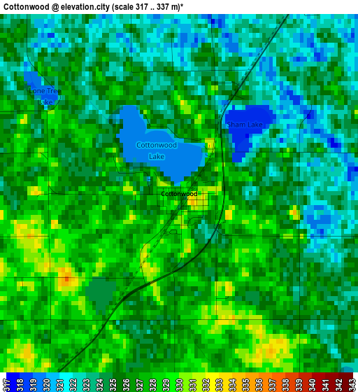
Below is the Elevation map of Cottonwood, which displays elevation range with different colors. Scale of the first map is from 317 to 337 m (1040 to 1106 ft) with average elevation of 325.1 meters (=1067 ft) [note 1]
These maps also provides idea of topography and contour of this city, they are displayed at different zoom levels. More info about maps, scale and edge coordinates you can find below images.
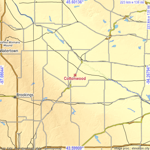
| \ | Map #1 | Topo.Map |
| Scale [m] | 317..337 m | × |
| Scale [ft] | 1040..1106 ft | × |
| Average | 325.1 m = 1067 ft | × |
| Width | 6.96 km = 4.3 mi | 222.6 km = 138.3 mi |
| Height | 6.96 km = 4.3 mi | 222.6 km = 138.3 mi |
| ↑Max Latitude | 44.640127° | 45.60136° |
| Latitude at center | 44.60885° | 44.60885° |
| ↓Min Latitude | 44.577556° | 43.59909° |
| ← Min Longitude | -95.718135° | -97.08044° |
| Longitude center | -95.67419° | -95.67419° |
| →Max Longitude | -95.630245° | -94.26794° |
Nearby cities:
Cities around Cottonwood sort by population:
• Marshall elevation 353 m
20.2 km,  206°
206°
• Montevideo 314 m
37.9 km,  354°
354°
• Redwood Falls 320 m
44.8 km,  99°
99°
• Granite Falls 281 m
24.6 km,  24°
24°
• Tracy 426 m
42 km,  174°
174°
• Canby 377 m
48.9 km,  283°
283°
• Dawson 318 m
46.9 km,  320°
320°
• Minneota 355 m
25.3 km,  257°
257°
• Clara City 321 m
45.5 km,  32°
32°
• Renville 328 m
41.7 km,  61°
61°
• Tyler 532 m
51.8 km,  224°
224°
• Ivanhoe 507 m
48.2 km,  250°
250°
Multilingual:
 En español:
Cottonwood elevación 328 m.
 En France:
Cottonwood élévation 328 m.
 Auf Deutsch:
Cottonwood höhe über dem Meeresspiegel ist 328 m.

Sources and notes:
- [note 1] Map square and city borders are not equal. Map elevation data is calculated only from area inside that square.
- [src 1] Elevation data from geonames database provided with same terms of usage.
- [src 2] The elevation map of Cottonwood is generated using elevation data from NASA's 3 arcsec (90m) resolution SRTM data.
- [src 3] Base (background) map © OpenStreetMap contributors tiles are generated by Geofabrik and OpenTopoMap.
Copyright & License:
This Cottonwood Elevation Map is licensed under CC BY-SA. You may reuse any part from this page, if you give a proper credit by linking to this URL:
 More info on terms of use page.