Edgerton elevation
Edgerton (Minnesota, Pipestone County), United States elevation is 481 meters and Edgerton elevation in feet is 1578 ft above sea level [src 1]. Edgerton is a populated place (feature code) with elevation that is 202 meters (663 ft) bigger than average city elevation in United States.
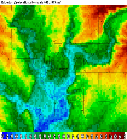
Below is the Elevation map of Edgerton, which displays elevation range with different colors. Scale of the first map is from 462 to 513 m (1516 to 1683 ft) with average elevation of 484.2 meters (=1589 ft) [note 1]
These maps also provides idea of topography and contour of this city, they are displayed at different zoom levels. More info about maps, scale and edge coordinates you can find below images.
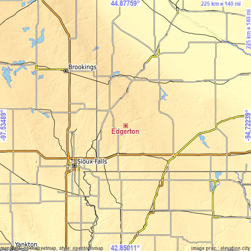
| \ | Map #1 | Topo.Map |
| Scale [m] | 462..513 m | × |
| Scale [ft] | 1516..1683 ft | × |
| Average | 484.2 m = 1589 ft | × |
| Width | 7.04 km = 4.4 mi | 225.4 km = 140.1 mi |
| Height | 7.04 km = 4.4 mi | 225.4 km = 140.1 mi |
| ↑Max Latitude | 43.904141° | 44.87759° |
| Latitude at center | 43.87247° | 43.87247° |
| ↓Min Latitude | 43.840782° | 42.85011° |
| ← Min Longitude | -96.172585° | -97.53489° |
| Longitude center | -96.12864° | -96.12864° |
| →Max Longitude | -96.084695° | -94.72239° |
Nearby cities:
Cities around Edgerton sort by population:
• Brandon elevation 413 m
47.1 km,  229°
229°
• Luverne 451 m
25.2 km,  195°
195°
• Pipestone 530 m
20.8 km,  313°
313°
• Dell Rapids 460 m
46.6 km,  263°
263°
• Rock Rapids 425 m
49.7 km,  184°
184°
• Flandreau 476 m
42.2 km,  297°
297°
• Slayton 494 m
32.5 km,  66°
66°
• Fulda 468 m
42.4 km,  90°
90°
• Adrian 475 m
30.7 km,  149°
149°
• Garretson 460 m
34.6 km,  240°
240°
• Baltic 448 m
50.6 km, 255°
• Tyler 532 m
45.1 km,  359°
359°
Multilingual:
 En español:
Edgerton elevación 481 m.
 En France:
Edgerton élévation 481 m.
 Auf Deutsch:
Edgerton höhe über dem Meeresspiegel ist 481 m.

Sources and notes:
- [note 1] Map square and city borders are not equal. Map elevation data is calculated only from area inside that square.
- [src 1] Elevation data from geonames database provided with same terms of usage.
- [src 2] The elevation map of Edgerton is generated using elevation data from NASA's 3 arcsec (90m) resolution SRTM data.
- [src 3] Base (background) map © OpenStreetMap contributors tiles are generated by Geofabrik and OpenTopoMap.
Copyright & License:
This Edgerton Elevation Map is licensed under CC BY-SA. You may reuse any part from this page, if you give a proper credit by linking to this URL:
 More info on terms of use page.