Rock Rapids elevation
Rock Rapids (Iowa, Lyon County), United States elevation is 425 meters and Rock Rapids elevation in feet is 1394 ft above sea level [src 1]. Rock Rapids is a seat of a second-order administrative division (feature code) with elevation that is 146 meters (479 ft) bigger than average city elevation in United States.
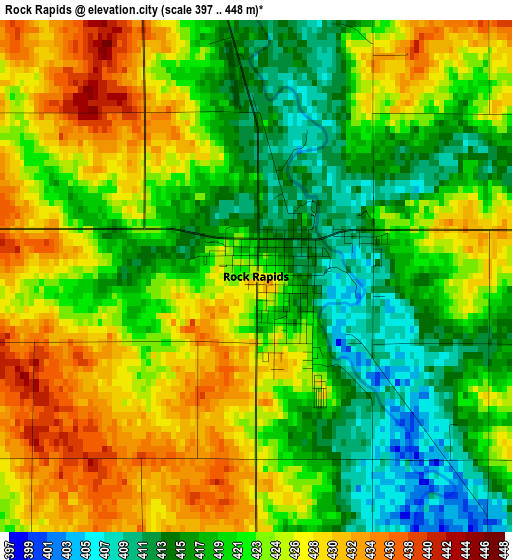
Below is the Elevation map of Rock Rapids, which displays elevation range with different colors. Scale of the first map is from 397 to 448 m (1302 to 1470 ft) with average elevation of 422.2 meters (=1385 ft) [note 1]
These maps also provides idea of topography and contour of this city, they are displayed at different zoom levels. More info about maps, scale and edge coordinates you can find below images.
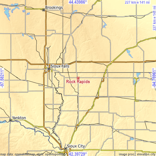
| \ | Map #1 | Topo.Map |
| Scale [m] | 397..448 m | × |
| Scale [ft] | 1302..1470 ft | × |
| Average | 422.2 m = 1385 ft | × |
| Width | 7.1 km = 4.4 mi | 227.1 km = 141.1 mi |
| Height | 7.1 km = 4.4 mi | 227.1 km = 141.1 mi |
| ↑Max Latitude | 43.459097° | 44.43986° |
| Latitude at center | 43.42719° | 43.42719° |
| ↓Min Latitude | 43.395266° | 42.39729° |
| ← Min Longitude | -96.219805° | -97.58211° |
| Longitude center | -96.17586° | -96.17586° |
| →Max Longitude | -96.131915° | -94.76961° |
Nearby cities:
Cities around Rock Rapids sort by population:
• Brandon elevation 413 m
37 km,  300°
300°
• Sioux Center 444 m
38.6 km,  179°
179°
• Harrisburg 436 m
42.1 km,  270°
270°
• Sheldon 432 m
37.7 km,  136°
136°
• Luverne 451 m
25.4 km,  353°
353°
• Rock Valley 380 m
26.5 km,  201°
201°
• Canton 389 m
36.5 km,  247°
247°
• Sibley 458 m
34.4 km,  95°
95°
• Hull 437 m
26.7 km,  172°
172°
• Adrian 475 m
30.3 km,  40°
40°
• Garretson 460 m
41.7 km,  320°
320°
• George 417 m
16.8 km,  123°
123°
Multilingual:
 En español:
Rock Rapids elevación 425 m.
 En France:
Rock Rapids élévation 425 m.
 Auf Deutsch:
Rock Rapids höhe über dem Meeresspiegel ist 425 m.

Sources and notes:
- [note 1] Map square and city borders are not equal. Map elevation data is calculated only from area inside that square.
- [src 1] Elevation data from geonames database provided with same terms of usage.
- [src 2] The elevation map of Rock Rapids is generated using elevation data from NASA's 3 arcsec (90m) resolution SRTM data.
- [src 3] Base (background) map © OpenStreetMap contributors tiles are generated by Geofabrik and OpenTopoMap.
Copyright & License:
This Rock Rapids Elevation Map is licensed under CC BY-SA. You may reuse any part from this page, if you give a proper credit by linking to this URL:
 More info on terms of use page.