Springfield elevation
Springfield (Minnesota, Brown County), United States elevation is 313 meters and Springfield elevation in feet is 1027 ft above sea level [src 1]. Springfield is a populated place (feature code) with elevation that is 34 meters (112 ft) bigger than average city elevation in United States.
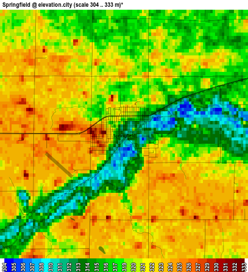
Below is the Elevation map of Springfield, which displays elevation range with different colors. Scale of the first map is from 304 to 333 m (997 to 1093 ft) with average elevation of 319.9 meters (=1050 ft) [note 1]
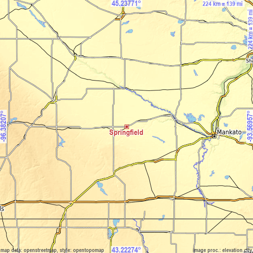
These maps also provides idea of topography and contour of this city, they are displayed at different zoom levels. More info about maps, scale and edge coordinates you can find below images.
| \ | Map #1 | Topo.Map |
| Scale [m] | 304..333 m | × |
| Scale [ft] | 997..1093 ft | × |
| Average | 319.9 m = 1050 ft | × |
| Width | 7 km = 4.3 mi | 224 km = 139.2 mi |
| Height | 7 km = 4.3 mi | 224 km = 139.2 mi |
| ↑Max Latitude | 44.270326° | 45.23771° |
| Latitude at center | 44.23885° | 44.23885° |
| ↓Min Latitude | 44.207357° | 43.22274° |
| ← Min Longitude | -95.019765° | -96.38207° |
| Longitude center | -94.97582° | -94.97582° |
| →Max Longitude | -94.931875° | -93.56957° |
Nearby cities:
Cities around Springfield sort by population:
• New Ulm elevation 273 m
41.8 km,  78°
78°
• Redwood Falls 320 m
35.2 km,  341°
341°
• Saint James 327 m
39.9 km,  135°
135°
• Windom 410 m
42.9 km,  195°
195°
• Sleepy Eye 309 m
21.1 km,  72°
72°
• Olivia 329 m
59.8 km,  358°
358°
• Madelia 311 m
49.2 km,  115°
115°
• Tracy 426 m
51.3 km,  269°
269°
• Mountain Lake 395 m
33.6 km,  173°
173°
• Winthrop 315 m
59.1 km,  55°
55°
• Fairfax 316 m
38.1 km,  32°
32°
• Hector 330 m
59.8 km,  20°
20°
Multilingual:
 En español:
Springfield elevación 313 m.
 En France:
Springfield élévation 313 m.
 Auf Deutsch:
Springfield höhe über dem Meeresspiegel ist 313 m.

Sources and notes:
- [note 1] Map square and city borders are not equal. Map elevation data is calculated only from area inside that square.
- [src 1] Elevation data from geonames database provided with same terms of usage.
- [src 2] The elevation map of Springfield is generated using elevation data from NASA's 3 arcsec (90m) resolution SRTM data.
- [src 3] Base (background) map © OpenStreetMap contributors tiles are generated by Geofabrik and OpenTopoMap.
Copyright & License:
This Springfield Elevation Map is licensed under CC BY-SA. You may reuse any part from this page, if you give a proper credit by linking to this URL:
 More info on terms of use page.