Hector elevation
Hector (Minnesota, Renville County), United States elevation is 330 meters and Hector elevation in feet is 1083 ft above sea level [src 1]. Hector is a populated place (feature code) with elevation that is 51 meters (167 ft) bigger than average city elevation in United States.
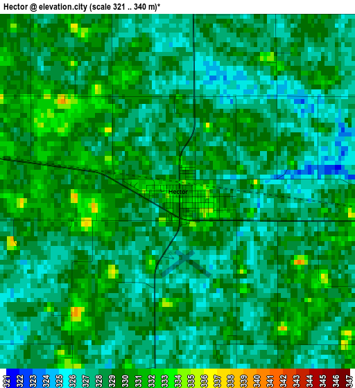
Below is the Elevation map of Hector, which displays elevation range with different colors. Scale of the first map is from 321 to 340 m (1053 to 1115 ft) with average elevation of 328.4 meters (=1077 ft) [note 1]
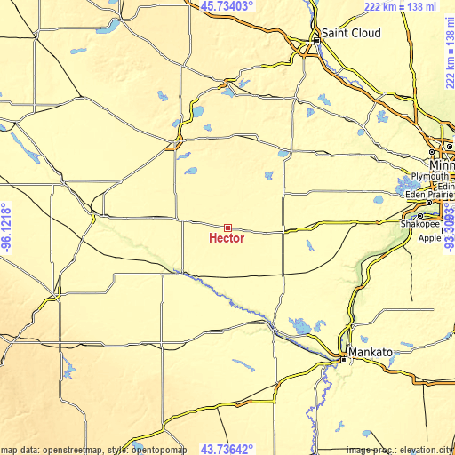
These maps also provides idea of topography and contour of this city, they are displayed at different zoom levels. More info about maps, scale and edge coordinates you can find below images.
| \ | Map #1 | Topo.Map |
| Scale [m] | 321..340 m | × |
| Scale [ft] | 1053..1115 ft | × |
| Average | 328.4 m = 1077 ft | × |
| Width | 6.94 km = 4.3 mi | 222.1 km = 138 mi |
| Height | 6.94 km = 4.3 mi | 222.1 km = 138 mi |
| ↑Max Latitude | 44.775054° | 45.73403° |
| Latitude at center | 44.74385° | 44.74385° |
| ↓Min Latitude | 44.712629° | 43.73642° |
| ← Min Longitude | -94.759495° | -96.1218° |
| Longitude center | -94.71555° | -94.71555° |
| →Max Longitude | -94.671605° | -93.3093° |
Nearby cities:
Cities around Hector sort by population:
• Willmar elevation 349 m
49.3 km,  328°
328°
• Hutchinson 326 m
31.6 km,  59°
59°
• Litchfield 345 m
45.1 km,  19°
19°
• Glencoe 301 m
44.6 km,  86°
86°
• Redwood Falls 320 m
39.1 km,  234°
234°
• Olivia 329 m
21.9 km,  279°
279°
• Gaylord 308 m
44.5 km,  118°
118°
• Dassel 337 m
49.5 km,  40°
40°
• Winthrop 315 m
35.5 km,  128°
128°
• Renville 328 m
39.5 km, 277°
• Fairfax 316 m
23.9 km,  181°
181°
• Atwater 372 m
44.2 km,  353°
353°
Multilingual:
 En español:
Hector elevación 330 m.
 En France:
Hector élévation 330 m.


Sources and notes:
- [note 1] Map square and city borders are not equal. Map elevation data is calculated only from area inside that square.
- [src 1] Elevation data from geonames database provided with same terms of usage.
- [src 2] The elevation map of Hector is generated using elevation data from NASA's 3 arcsec (90m) resolution SRTM data.
- [src 3] Base (background) map © OpenStreetMap contributors tiles are generated by Geofabrik and OpenTopoMap.
Copyright & License:
This Hector Elevation Map is licensed under CC BY-SA. You may reuse any part from this page, if you give a proper credit by linking to this URL:
 More info on terms of use page.