Fairfax elevation
Fairfax (Minnesota, Renville County), United States elevation is 316 meters and Fairfax elevation in feet is 1037 ft above sea level [src 1]. Fairfax is a populated place (feature code) with elevation that is 37 meters (121 ft) bigger than average city elevation in United States.
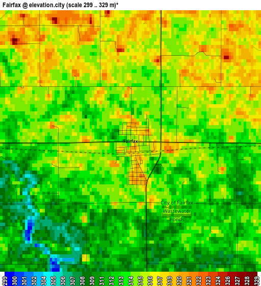
Below is the Elevation map of Fairfax, which displays elevation range with different colors. Scale of the first map is from 299 to 329 m (981 to 1079 ft) with average elevation of 314 meters (=1030 ft) [note 1]
These maps also provides idea of topography and contour of this city, they are displayed at different zoom levels. More info about maps, scale and edge coordinates you can find below images.
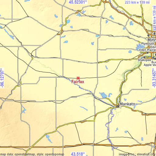
| \ | Map #1 | Topo.Map |
| Scale [m] | 299..329 m | × |
| Scale [ft] | 981..1079 ft | × |
| Average | 314 m = 1030 ft | × |
| Width | 6.97 km = 4.3 mi | 222.9 km = 138.5 mi |
| Height | 6.97 km = 4.3 mi | 222.9 km = 138.5 mi |
| ↑Max Latitude | 44.56045° | 45.52301° |
| Latitude at center | 44.52913° | 44.52913° |
| ↓Min Latitude | 44.497793° | 43.518° |
| ← Min Longitude | -94.764765° | -96.12707° |
| Longitude center | -94.72082° | -94.72082° |
| →Max Longitude | -94.676875° | -93.31457° |
Nearby cities:
Cities around Fairfax sort by population:
• Hutchinson elevation 326 m
48.6 km,  34°
34°
• New Ulm 273 m
31.7 km,  139°
139°
• Redwood Falls 320 m
31.4 km,  272°
272°
• Sleepy Eye 309 m
25.8 km,  180°
180°
• Olivia 329 m
34.8 km,  322°
322°
• Gaylord 308 m
39.7 km,  86°
86°
• Arlington 304 m
51.5 km,  80°
80°
• Springfield 313 m
38.1 km,  212°
212°
• Winthrop 315 m
28.1 km, 86°
• Renville 328 m
48.4 km,  306°
306°
• Nicollet 298 m
50.9 km,  123°
123°
• Hector 330 m
23.9 km,  1°
1°
Multilingual:
 En español:
Fairfax elevación 316 m.
 En France:
Fairfax élévation 316 m.


Sources and notes:
- [note 1] Map square and city borders are not equal. Map elevation data is calculated only from area inside that square.
- [src 1] Elevation data from geonames database provided with same terms of usage.
- [src 2] The elevation map of Fairfax is generated using elevation data from NASA's 3 arcsec (90m) resolution SRTM data.
- [src 3] Base (background) map © OpenStreetMap contributors tiles are generated by Geofabrik and OpenTopoMap.
Copyright & License:
This Fairfax Elevation Map is licensed under CC BY-SA. You may reuse any part from this page, if you give a proper credit by linking to this URL:
 More info on terms of use page.