Gaylord elevation
Gaylord (Minnesota, Sibley County), United States elevation is 308 meters and Gaylord elevation in feet is 1010 ft above sea level [src 1]. Gaylord is a seat of a second-order administrative division (feature code) with elevation that is 29 meters (95 ft) bigger than average city elevation in United States.
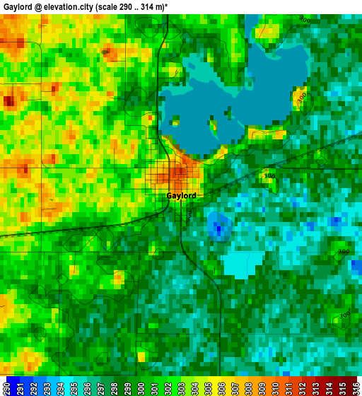
Below is the Elevation map of Gaylord, which displays elevation range with different colors. Scale of the first map is from 290 to 314 m (951 to 1030 ft) with average elevation of 299.4 meters (=982 ft) [note 1]
These maps also provides idea of topography and contour of this city, they are displayed at different zoom levels. More info about maps, scale and edge coordinates you can find below images.
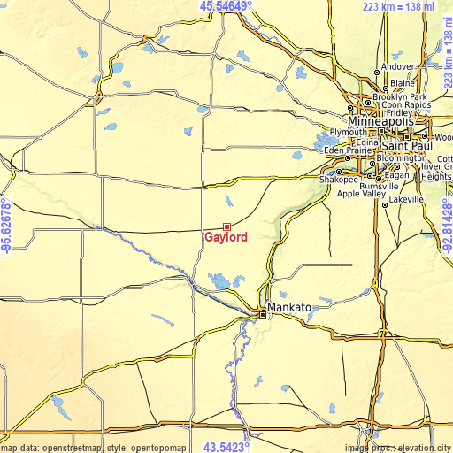
| \ | Map #1 | Topo.Map |
| Scale [m] | 290..314 m | × |
| Scale [ft] | 951..1030 ft | × |
| Average | 299.4 m = 982 ft | × |
| Width | 6.96 km = 4.3 mi | 222.8 km = 138.4 mi |
| Height | 6.96 km = 4.3 mi | 222.8 km = 138.4 mi |
| ↑Max Latitude | 44.584327° | 45.54649° |
| Latitude at center | 44.55302° | 44.55302° |
| ↓Min Latitude | 44.521696° | 43.5423° |
| ← Min Longitude | -94.264475° | -95.62678° |
| Longitude center | -94.22053° | -94.22053° |
| →Max Longitude | -94.176585° | -92.81428° |
Nearby cities:
Cities around Gaylord sort by population:
• Hutchinson elevation 326 m
39 km,  342°
342°
• New Ulm 273 m
32.8 km,  215°
215°
• Saint Peter 233 m
32.9 km,  140°
140°
• Belle Plaine 259 m
36.6 km,  77°
77°
• Glencoe 301 m
24.6 km,  12°
12°
• Le Sueur 232 m
26.3 km,  112°
112°
• Norwood Young America 302 m
34.1 km,  43°
43°
• Arlington 304 m
12.7 km,  60°
60°
• Young America (historical) 313 m
35.2 km, 43°
• Norwood (historical) 301 m
33.3 km, 44°
• Winthrop 315 m
11.6 km,  264°
264°
• Nicollet 298 m
30.9 km,  175°
175°
Multilingual:
 En español:
Gaylord elevación 308 m.
 En France:
Gaylord élévation 308 m.


Sources and notes:
- [note 1] Map square and city borders are not equal. Map elevation data is calculated only from area inside that square.
- [src 1] Elevation data from geonames database provided with same terms of usage.
- [src 2] The elevation map of Gaylord is generated using elevation data from NASA's 3 arcsec (90m) resolution SRTM data.
- [src 3] Base (background) map © OpenStreetMap contributors tiles are generated by Geofabrik and OpenTopoMap.
Copyright & License:
This Gaylord Elevation Map is licensed under CC BY-SA. You may reuse any part from this page, if you give a proper credit by linking to this URL:
 More info on terms of use page.