Millington elevation
Millington (Michigan, Tuscola County), United States elevation is 230 meters and Millington elevation in feet is 755 ft above sea level [src 1]. Millington is a populated place (feature code) with elevation that is 49 meters (161 ft) smaller than average city elevation in United States.
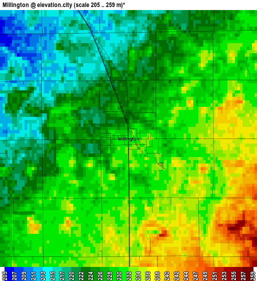
Below is the Elevation map of Millington, which displays elevation range with different colors. Scale of the first map is from 205 to 259 m (673 to 850 ft) with average elevation of 228 meters (=748 ft) [note 1]
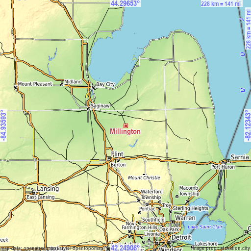
These maps also provides idea of topography and contour of this city, they are displayed at different zoom levels. More info about maps, scale and edge coordinates you can find below images.
| \ | Map #1 | Topo.Map |
| Scale [m] | 205..259 m | × |
| Scale [ft] | 673..850 ft | × |
| Average | 228 m = 748 ft | × |
| Width | 7.11 km = 4.4 mi | 227.7 km = 141.5 mi |
| Height | 7.11 km = 4.4 mi | 227.6 km = 141.4 mi |
| ↑Max Latitude | 43.313394° | 44.29653° |
| Latitude at center | 43.28141° | 43.28141° |
| ↓Min Latitude | 43.24941° | 42.24906° |
| ← Min Longitude | -83.573625° | -84.93593° |
| Longitude center | -83.52968° | -83.52968° |
| →Max Longitude | -83.485735° | -82.12343° |
Nearby cities:
Cities around Millington sort by population:
• Beecher elevation 245 m
25.1 km,  212°
212°
• Bridgeport 184 m
29.8 km,  286°
286°
• Frankenmuth 194 m
17.8 km, 288°
• Davison 242 m
27.4 km,  178°
178°
• Caro 222 m
25.6 km,  24°
24°
• Mount Morris 235 m
22.5 km,  216°
216°
• Vassar 196 m
11 km,  336°
336°
• Clio 220 m
20.2 km,  235°
235°
• Birch Run 197 m
21.7 km,  260°
260°
• Reese 192 m
23.1 km,  324°
324°
• Barnes Lake-Millers Lake 243 m
20.9 km,  122°
122°
• North Branch 248 m
27.6 km,  102°
102°
Multilingual:
 En español:
Millington elevación 230 m.
 En France:
Millington élévation 230 m.
 Auf Deutsch:
Millington höhe über dem Meeresspiegel ist 230 m.

Sources and notes:
- [note 1] Map square and city borders are not equal. Map elevation data is calculated only from area inside that square.
- [src 1] Elevation data from geonames database provided with same terms of usage.
- [src 2] The elevation map of Millington is generated using elevation data from NASA's 3 arcsec (90m) resolution SRTM data.
- [src 3] Base (background) map © OpenStreetMap contributors tiles are generated by Geofabrik and OpenTopoMap.
Copyright & License:
This Millington Elevation Map is licensed under CC BY-SA. You may reuse any part from this page, if you give a proper credit by linking to this URL:
 More info on terms of use page.