Caro elevation
Caro (Michigan, Tuscola County), United States elevation is 222 meters and Caro elevation in feet is 728 ft above sea level [src 1]. Caro is a seat of a second-order administrative division (feature code) with elevation that is 57 meters (187 ft) smaller than average city elevation in United States.
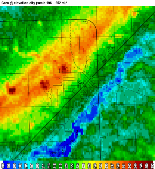
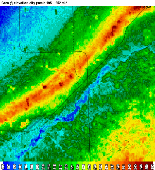
Below is the Elevation map of Caro, which displays elevation range with different colors. Scale of the first map is from 196 to 252 m (643 to 827 ft) with average elevation of 219.2 meters (=719 ft) [note 1]
These maps also provides idea of topography and contour of this city, they are displayed at different zoom levels. More info about maps, scale and edge coordinates you can find below images.
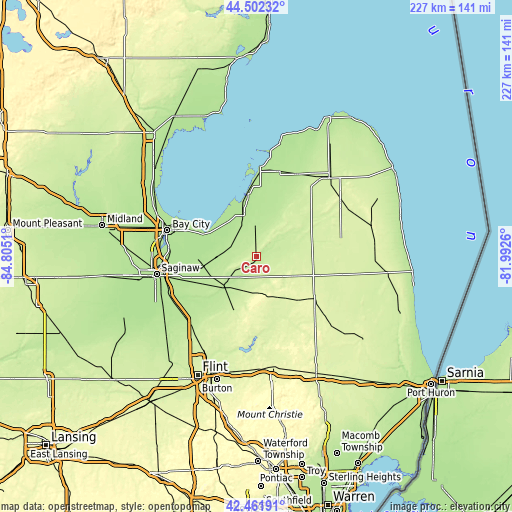
| \ | Map #1 | Map #2 | Topo.Map |
| Scale [m] | 196..252 m | 195..252 m | × |
| Scale [ft] | 643..827 ft | 640..827 ft | × |
| Average | 219.2 m = 719 ft | 217.4 m = 713 ft | × |
| Width | 7.09 km = 4.4 mi | 14.18 km = 8.8 mi | 226.9 km = 141 mi |
| Height | 7.09 km = 4.4 mi | 14.18 km = 8.8 mi | 226.9 km = 141 mi |
| ↑Max Latitude | 43.522603° | 43.55446° | 44.50232° |
| Latitude at center | 43.49073° | 43.49073° | 43.49073° |
| ↓Min Latitude | 43.45884° | 43.426933° | 42.46191° |
| ← Min Longitude | -83.442795° | -83.486741° | -84.8051° |
| Longitude center | -83.39885° | -83.39885° | -83.39885° |
| →Max Longitude | -83.354905° | -83.310959° | -81.9926° |
Nearby cities:
Cities around Caro sort by population:
• Frankenmuth elevation 194 m
32.6 km,  237°
237°
• Essexville 178 m
38.3 km,  291°
291°
• Kilmanagh 191 m
29.7 km,  6°
6°
• Vassar 196 m
19.9 km,  228°
228°
• Cass City 227 m
21.8 km,  55°
55°
• Marlette 255 m
31.5 km,  125°
125°
• Sebewaing 180 m
27.2 km,  351°
351°
• Reese 192 m
24.4 km,  259°
259°
• Pigeon 191 m
39.1 km,  15°
15°
• Barnes Lake-Millers Lake 243 m
35.3 km,  168°
168°
• Millington 230 m
25.6 km,  204°
204°
• North Branch 248 m
33.3 km,  150°
150°
Multilingual:
 En español:
Caro elevación 222 m.
 En France:
Caro élévation 222 m.


Sources and notes:
- [note 1] Map square and city borders are not equal. Map elevation data is calculated only from area inside that square.
- [src 1] Elevation data from geonames database provided with same terms of usage.
- [src 2] The elevation map of Caro is generated using elevation data from NASA's 3 arcsec (90m) resolution SRTM data.
- [src 3] Base (background) map © OpenStreetMap contributors tiles are generated by Geofabrik and OpenTopoMap.
Copyright & License:
This Caro Elevation Map is licensed under CC BY-SA. You may reuse any part from this page, if you give a proper credit by linking to this URL:
 More info on terms of use page.