Barnes Lake-Millers Lake elevation
Barnes Lake-Millers Lake (Michigan, Lapeer County), United States elevation is 243 meters and Barnes Lake-Millers Lake elevation in feet is 797 ft above sea level [src 1]. Barnes Lake-Millers Lake is a populated place (feature code) with elevation that is 36 meters (118 ft) smaller than average city elevation in United States.
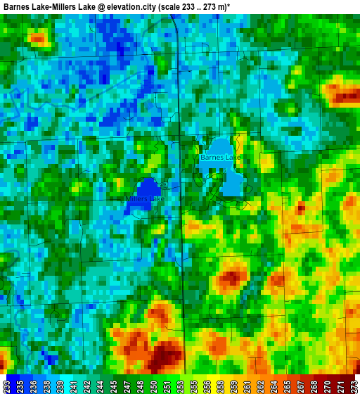
Below is the Elevation map of Barnes Lake-Millers Lake, which displays elevation range with different colors. Scale of the first map is from 233 to 273 m (764 to 896 ft) with average elevation of 246.6 meters (=809 ft) [note 1]
These maps also provides idea of topography and contour of this city, they are displayed at different zoom levels. More info about maps, scale and edge coordinates you can find below images.
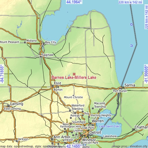
| \ | Map #1 | Topo.Map |
| Scale [m] | 233..273 m | × |
| Scale [ft] | 764..896 ft | × |
| Average | 246.6 m = 809 ft | × |
| Width | 7.13 km = 4.4 mi | 228 km = 141.7 mi |
| Height | 7.13 km = 4.4 mi | 228 km = 141.7 mi |
| ↑Max Latitude | 43.211597° | 44.1964° |
| Latitude at center | 43.17956° | 43.17956° |
| ↓Min Latitude | 43.147506° | 42.1455° |
| ← Min Longitude | -83.356245° | -84.71855° |
| Longitude center | -83.3123° | -83.3123° |
| →Max Longitude | -83.268355° | -81.90605° |
Nearby cities:
Cities around Barnes Lake-Millers Lake sort by population:
• Burton elevation 239 m
31.8 km,  230°
230°
• Beecher 245 m
32.6 km,  252°
252°
• Lapeer 266 m
14.3 km,  182°
182°
• Davison 242 m
23.2 km, 226°
• Imlay City 252 m
25.7 km,  132°
132°
• Mount Morris 235 m
31.8 km,  257°
257°
• Vassar 196 m
30.6 km,  314°
314°
• Goodrich 270 m
33.2 km,  208°
208°
• Marlette 255 m
24.9 km,  48°
48°
• Brown City 252 m
26.4 km,  82°
82°
• Millington 230 m
20.9 km,  302°
302°
• North Branch 248 m
10.9 km,  59°
59°
Multilingual:
 En español:
Barnes Lake-Millers Lake elevación 243 m.
 En France:
Barnes Lake-Millers Lake élévation 243 m.
 Auf Deutsch:
Barnes Lake-Millers Lake höhe über dem Meeresspiegel ist 243 m.
 На русском:
Barnes Lake-Millers Lake высота над уровнем моря 243 м
Sources and notes:
- [note 1] Map square and city borders are not equal. Map elevation data is calculated only from area inside that square.
- [src 1] Elevation data from geonames database provided with same terms of usage.
- [src 2] The elevation map of Barnes Lake-Millers Lake is generated using elevation data from NASA's 3 arcsec (90m) resolution SRTM data.
- [src 3] Base (background) map © OpenStreetMap contributors tiles are generated by Geofabrik and OpenTopoMap.
Copyright & License:
This Barnes Lake-Millers Lake Elevation Map is licensed under CC BY-SA. You may reuse any part from this page, if you give a proper credit by linking to this URL:
 More info on terms of use page.