Bridgeport elevation
Bridgeport (Michigan, Saginaw County), United States elevation is 184 meters and Bridgeport elevation in feet is 604 ft above sea level [src 1]. Bridgeport is a populated place (feature code) with elevation that is 95 meters (312 ft) smaller than average city elevation in United States.
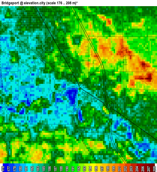
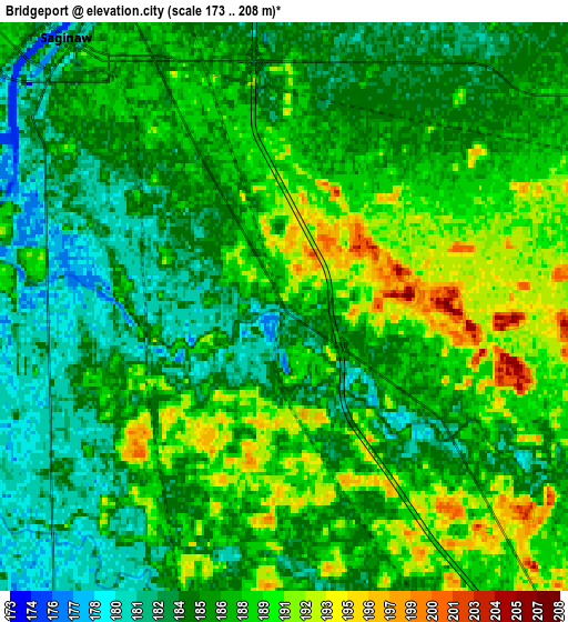
Below is the Elevation map of Bridgeport, which displays elevation range with different colors. Scale of the first map is from 176 to 208 m (577 to 682 ft) with average elevation of 187.5 meters (=615 ft) [note 1]
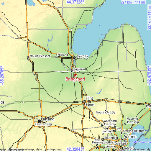
These maps also provides idea of topography and contour of this city, they are displayed at different zoom levels. More info about maps, scale and edge coordinates you can find below images.
| \ | Map #1 | Map #2 | Topo.Map |
| Scale [m] | 176..208 m | 173..208 m | × |
| Scale [ft] | 577..682 ft | 568..682 ft | × |
| Average | 187.5 m = 615 ft | 186.6 m = 612 ft | × |
| Width | 7.11 km = 4.4 mi | 14.21 km = 8.8 mi | 227.4 km = 141.3 mi |
| Height | 7.11 km = 4.4 mi | 14.21 km = 8.8 mi | 227.4 km = 141.3 mi |
| ↑Max Latitude | 43.391412° | 43.423338° | 44.37328° |
| Latitude at center | 43.35947° | 43.35947° | 43.35947° |
| ↓Min Latitude | 43.327511° | 43.295535° | 42.32843° |
| ← Min Longitude | -83.925585° | -83.969531° | -85.28789° |
| Longitude center | -83.88164° | -83.88164° | -83.88164° |
| →Max Longitude | -83.837695° | -83.793749° | -82.47539° |
Nearby cities:
Cities around Bridgeport sort by population:
• Saginaw elevation 178 m
8.7 km,  320°
320°
• Saginaw Township North 191 m
15.1 km, 317°
• Buena Vista 184 m
6.9 km,  348°
348°
• Shields 184 m
15.4 km,  293°
293°
• Carrollton 183 m
11.7 km,  340°
340°
• Frankenmuth 194 m
12 km,  104°
104°
• Saint Charles 182 m
22.1 km,  251°
251°
• Montrose 206 m
20.3 km,  182°
182°
• Zilwaukee 180 m
13.4 km, 346°
• Birch Run 197 m
14 km,  149°
149°
• Reese 192 m
18.1 km,  55°
55°
• Burt 198 m
13.8 km,  188°
188°
Multilingual:
 En español:
Bridgeport elevación 184 m.
 En France:
Bridgeport élévation 184 m.
 Auf Deutsch:
Bridgeport höhe über dem Meeresspiegel ist 184 m.

Sources and notes:
- [note 1] Map square and city borders are not equal. Map elevation data is calculated only from area inside that square.
- [src 1] Elevation data from geonames database provided with same terms of usage.
- [src 2] The elevation map of Bridgeport is generated using elevation data from NASA's 3 arcsec (90m) resolution SRTM data.
- [src 3] Base (background) map © OpenStreetMap contributors tiles are generated by Geofabrik and OpenTopoMap.
Copyright & License:
This Bridgeport Elevation Map is licensed under CC BY-SA. You may reuse any part from this page, if you give a proper credit by linking to this URL:
 More info on terms of use page.