Rochester elevation
Rochester (Indiana, Fulton County), United States elevation is 239 meters and Rochester elevation in feet is 784 ft above sea level [src 1]. Rochester is a seat of a second-order administrative division (feature code) with elevation that is 40 meters (131 ft) smaller than average city elevation in United States.
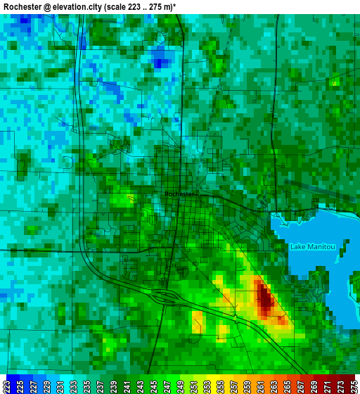
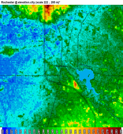
Below is the Elevation map of Rochester, which displays elevation range with different colors. Scale of the first map is from 223 to 275 m (732 to 902 ft) with average elevation of 237.3 meters (=779 ft) [note 1]
These maps also provides idea of topography and contour of this city, they are displayed at different zoom levels. More info about maps, scale and edge coordinates you can find below images.
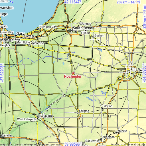
| \ | Map #1 | Map #2 | Topo.Map |
| Scale [m] | 223..275 m | 222..285 m | × |
| Scale [ft] | 732..902 ft | 728..935 ft | × |
| Average | 237.3 m = 779 ft | 238.8 m = 783 ft | × |
| Width | 7.37 km = 4.6 mi | 14.74 km = 9.2 mi | 235.8 km = 146.5 mi |
| Height | 7.37 km = 4.6 mi | 14.74 km = 9.2 mi | 235.8 km = 146.5 mi |
| ↑Max Latitude | 41.097885° | 41.130993° | 42.11647° |
| Latitude at center | 41.06476° | 41.06476° | 41.06476° |
| ↓Min Latitude | 41.031618° | 40.99846° | 39.99596° |
| ← Min Longitude | -86.259775° | -86.303721° | -87.62208° |
| Longitude center | -86.21583° | -86.21583° | -86.21583° |
| →Max Longitude | -86.171885° | -86.127939° | -84.80958° |
Nearby cities:
Cities around Rochester sort by population:
• Logansport elevation 196 m
36.5 km,  198°
198°
• Warsaw 251 m
36 km,  57°
57°
• Peru 203 m
36.7 km,  160°
160°
• Plymouth 246 m
32 km,  345°
345°
• Winona Lake 253 m
37.6 km, 61°
• Dunkirk 187 m
37.4 km, 203°
• Winamac 217 m
32.5 km,  267°
267°
• Bourbon 258 m
27 km,  17°
17°
• Argos 246 m
19.2 km,  0°
0°
• Culver 236 m
24.4 km,  314°
314°
• Bass Lake 220 m
36 km,  296°
296°
• Akron 261 m
16 km,  100°
100°
Multilingual:
 En español:
Rochester elevación 239 m.
 En France:
Rochester élévation 239 m.
 Auf Deutsch:
Rochester höhe über dem Meeresspiegel ist 239 m.

Sources and notes:
- [note 1] Map square and city borders are not equal. Map elevation data is calculated only from area inside that square.
- [src 1] Elevation data from geonames database provided with same terms of usage.
- [src 2] The elevation map of Rochester is generated using elevation data from NASA's 3 arcsec (90m) resolution SRTM data.
- [src 3] Base (background) map © OpenStreetMap contributors tiles are generated by Geofabrik and OpenTopoMap.
Copyright & License:
This Rochester Elevation Map is licensed under CC BY-SA. You may reuse any part from this page, if you give a proper credit by linking to this URL:
 More info on terms of use page.