Culver elevation
Culver (Indiana, Marshall County), United States elevation is 236 meters and Culver elevation in feet is 774 ft above sea level [src 1]. Culver is a populated place (feature code) with elevation that is 43 meters (141 ft) smaller than average city elevation in United States.
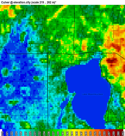
Below is the Elevation map of Culver, which displays elevation range with different colors. Scale of the first map is from 219 to 262 m (719 to 860 ft) with average elevation of 230.8 meters (=757 ft) [note 1]
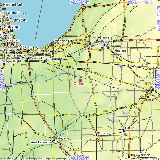
These maps also provides idea of topography and contour of this city, they are displayed at different zoom levels. More info about maps, scale and edge coordinates you can find below images.
| \ | Map #1 | Topo.Map |
| Scale [m] | 219..262 m | × |
| Scale [ft] | 719..860 ft | × |
| Average | 230.8 m = 757 ft | × |
| Width | 7.35 km = 4.6 mi | 235.2 km = 146.1 mi |
| Height | 7.35 km = 4.6 mi | 235.2 km = 146.1 mi |
| ↑Max Latitude | 41.251977° | 42.26814° |
| Latitude at center | 41.21893° | 41.21893° |
| ↓Min Latitude | 41.185866° | 40.15261° |
| ← Min Longitude | -86.467005° | -87.82931° |
| Longitude center | -86.42306° | -86.42306° |
| →Max Longitude | -86.379115° | -85.01681° |
Nearby cities:
Cities around Culver sort by population:
• Plymouth elevation 246 m
16.8 km,  34°
34°
• Rochester 239 m
24.4 km,  134°
134°
• Bremen 261 m
34.2 km,  42°
42°
• Knox 219 m
18.9 km,  296°
296°
• Winamac 217 m
24 km,  218°
218°
• Walkerton 222 m
28 km,  349°
349°
• North Liberty 224 m
35.1 km,  359°
359°
• Bourbon 258 m
27 km,  71°
71°
• North Judson 219 m
29.5 km,  269°
269°
• Argos 246 m
17.6 km,  83°
83°
• Koontz Lake 229 m
22.8 km, 346°
• Bass Lake 220 m
15 km, 265°
Multilingual:
 En español:
Culver elevación 236 m.
 En France:
Culver élévation 236 m.


Sources and notes:
- [note 1] Map square and city borders are not equal. Map elevation data is calculated only from area inside that square.
- [src 1] Elevation data from geonames database provided with same terms of usage.
- [src 2] The elevation map of Culver is generated using elevation data from NASA's 3 arcsec (90m) resolution SRTM data.
- [src 3] Base (background) map © OpenStreetMap contributors tiles are generated by Geofabrik and OpenTopoMap.
Copyright & License:
This Culver Elevation Map is licensed under CC BY-SA. You may reuse any part from this page, if you give a proper credit by linking to this URL:
 More info on terms of use page.