Warren elevation
Warren (Illinois, Jo Daviess County), United States elevation is 302 meters and Warren elevation in feet is 991 ft above sea level [src 1]. Warren is a populated place (feature code) with elevation that is 23 meters (75 ft) bigger than average city elevation in United States.
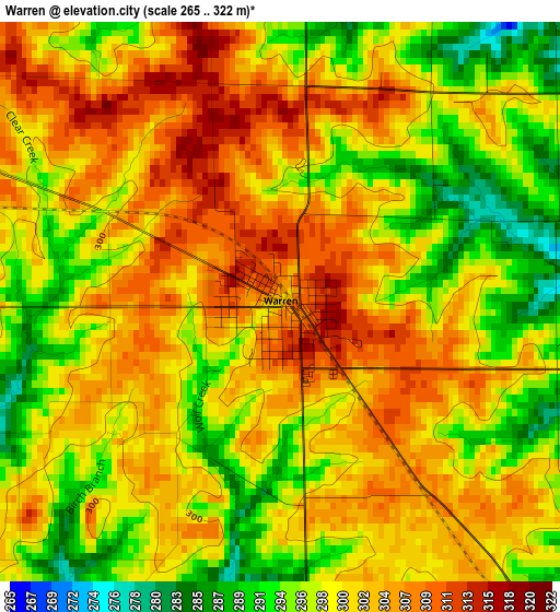
Below is the Elevation map of Warren, which displays elevation range with different colors. Scale of the first map is from 265 to 322 m (869 to 1056 ft) with average elevation of 300.2 meters (=985 ft) [note 1]
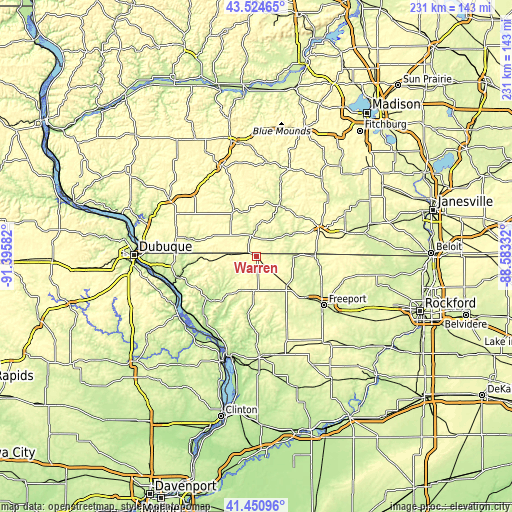
These maps also provides idea of topography and contour of this city, they are displayed at different zoom levels. More info about maps, scale and edge coordinates you can find below images.
| \ | Map #1 | Topo.Map |
| Scale [m] | 265..322 m | × |
| Scale [ft] | 869..1056 ft | × |
| Average | 300.2 m = 985 ft | × |
| Width | 7.21 km = 4.5 mi | 230.6 km = 143.3 mi |
| Height | 7.21 km = 4.5 mi | 230.6 km = 143.3 mi |
| ↑Max Latitude | 42.528793° | 43.52465° |
| Latitude at center | 42.4964° | 42.4964° |
| ↓Min Latitude | 42.46399° | 41.45096° |
| ← Min Longitude | -90.033515° | -91.39582° |
| Longitude center | -89.98957° | -89.98957° |
| →Max Longitude | -89.945625° | -88.58332° |
Nearby cities:
Cities around Warren sort by population:
• Freeport elevation 237 m
37.5 km,  126°
126°
• Monroe 322 m
31 km,  67°
67°
• Georgetown 276 m
41.8 km,  161°
161°
• Galena 197 m
37.1 km,  256°
256°
• Lena 293 m
18.9 km, 133°
• Darlington 264 m
23.3 km,  333°
333°
• Cuba City 309 m
38.1 km,  288°
288°
• Stockton 308 m
16.4 km,  184°
184°
• Hazel Green 296 m
36.7 km,  276°
276°
• Monticello 255 m
42.6 km,  49°
49°
• Shullsburg 306 m
21.5 km, 293°
• The Galena Territory 278 m
29.9 km,  247°
247°
Multilingual:
 En español:
Warren elevación 302 m.
 En France:
Warren élévation 302 m.


Sources and notes:
- [note 1] Map square and city borders are not equal. Map elevation data is calculated only from area inside that square.
- [src 1] Elevation data from geonames database provided with same terms of usage.
- [src 2] The elevation map of Warren is generated using elevation data from NASA's 3 arcsec (90m) resolution SRTM data.
- [src 3] Base (background) map © OpenStreetMap contributors tiles are generated by Geofabrik and OpenTopoMap.
Copyright & License:
This Warren Elevation Map is licensed under CC BY-SA. You may reuse any part from this page, if you give a proper credit by linking to this URL:
 More info on terms of use page.