Monticello elevation
Monticello (Wisconsin, Green County), United States elevation is 255 meters and Monticello elevation in feet is 837 ft above sea level [src 1]. Monticello is a populated place (feature code) with elevation that is 24 meters (79 ft) smaller than average city elevation in United States.
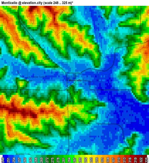
Below is the Elevation map of Monticello, which displays elevation range with different colors. Scale of the first map is from 248 to 325 m (814 to 1066 ft) with average elevation of 272.7 meters (=895 ft) [note 1]
These maps also provides idea of topography and contour of this city, they are displayed at different zoom levels. More info about maps, scale and edge coordinates you can find below images.
| \ | Map #1 | Topo.Map |
| Scale [m] | 248..325 m | × |
| Scale [ft] | 814..1066 ft | × |
| Average | 272.7 m = 895 ft | × |
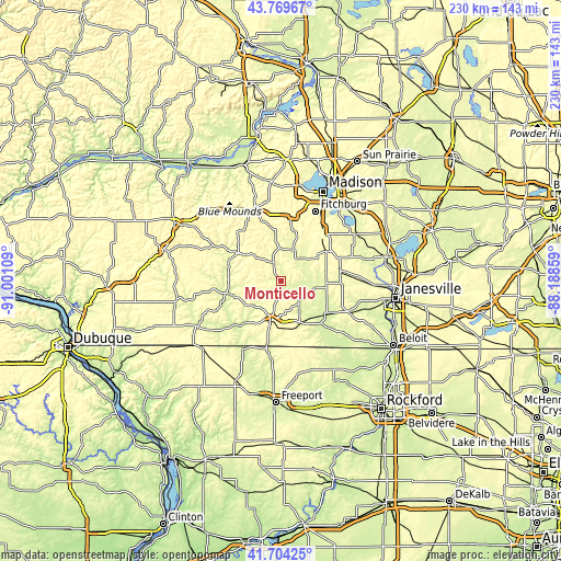
| Width | 7.18 km = 4.5 mi | 229.7 km = 142.7 mi |
| Height | 7.18 km = 4.5 mi | 229.6 km = 142.7 mi |
| ↑Max Latitude | 42.777824° | 43.76967° |
| Latitude at center | 42.74556° | 42.74556° |
| ↓Min Latitude | 42.713279° | 41.70425° |
| ← Min Longitude | -89.638785° | -91.00109° |
| Longitude center | -89.59484° | -89.59484° |
| →Max Longitude | -89.550895° | -88.18859° |
Nearby cities:
Cities around Monticello sort by population:
• Fitchburg elevation 310 m
26 km,  23°
23°
• Verona 298 m
27.7 km,  10°
10°
• Monroe 322 m
16.5 km,  192°
192°
• Oregon 289 m
26.4 km,  40°
40°
• Evansville 281 m
24.4 km,  80°
80°
• Brodhead 243 m
22.8 km,  128°
128°
• Belleville 267 m
13.5 km, 20°
• New Glarus 278 m
8.3 km,  336°
336°
• Rutland 289 m
24.9 km,  53°
53°
• Decatur 251 m
19.4 km, 129°
• Brooklyn 303 m
21.9 km,  56°
56°
• Albany 246 m
13.6 km,  108°
108°
Multilingual:
 En español:
Monticello elevación 255 m.
 En France:
Monticello élévation 255 m.
 Auf Deutsch:
Monticello höhe über dem Meeresspiegel ist 255 m.

Sources and notes:
- [note 1] Map square and city borders are not equal. Map elevation data is calculated only from area inside that square.
- [src 1] Elevation data from geonames database provided with same terms of usage.
- [src 2] The elevation map of Monticello is generated using elevation data from NASA's 3 arcsec (90m) resolution SRTM data.
- [src 3] Base (background) map © OpenStreetMap contributors tiles are generated by Geofabrik and OpenTopoMap.
Copyright & License:
This Monticello Elevation Map is licensed under CC BY-SA. You may reuse any part from this page, if you give a proper credit by linking to this URL:
 More info on terms of use page.