Georgetown elevation
Georgetown (Illinois, Carroll County), United States elevation is 276 meters and Georgetown elevation in feet is 906 ft above sea level [src 1]. Georgetown is a populated place (feature code) with elevation that is 3 meters (10 ft) smaller than average city elevation in United States.
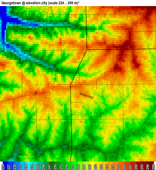
Below is the Elevation map of Georgetown, which displays elevation range with different colors. Scale of the first map is from 224 to 299 m (735 to 981 ft) with average elevation of 265.2 meters (=870 ft) [note 1]
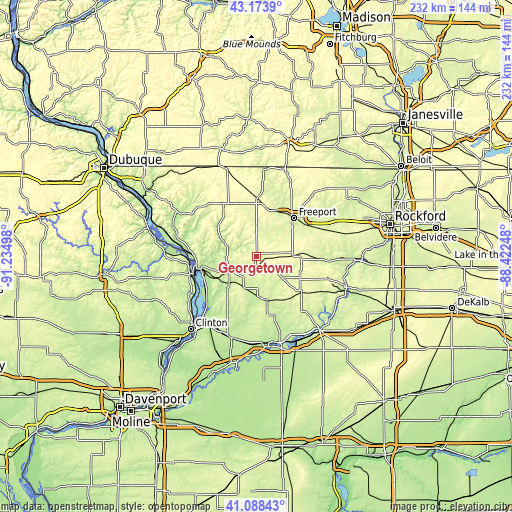
These maps also provides idea of topography and contour of this city, they are displayed at different zoom levels. More info about maps, scale and edge coordinates you can find below images.
| \ | Map #1 | Topo.Map |
| Scale [m] | 224..299 m | × |
| Scale [ft] | 735..981 ft | × |
| Average | 265.2 m = 870 ft | × |
| Width | 7.25 km = 4.5 mi | 231.9 km = 144.1 mi |
| Height | 7.25 km = 4.5 mi | 231.9 km = 144.1 mi |
| ↑Max Latitude | 42.172328° | 43.1739° |
| Latitude at center | 42.13975° | 42.13975° |
| ↓Min Latitude | 42.107156° | 41.08843° |
| ← Min Longitude | -89.872675° | -91.23498° |
| Longitude center | -89.82873° | -89.82873° |
| →Max Longitude | -89.784785° | -88.42248° |
Nearby cities:
Cities around Georgetown sort by population:
• Freeport elevation 237 m
24.4 km,  44°
44°
• Sterling 203 m
40.5 km,  164°
164°
• Morrison 209 m
38.4 km,  197°
197°
• Fulton 199 m
40.8 km,  222°
222°
• Savanna 184 m
27.5 km,  259°
259°
• Mount Morris 281 m
34.3 km,  106°
106°
• Lena 293 m
26.7 km,  1°
1°
• Polo 264 m
26.8 km,  129°
129°
• Stockton 308 m
27.6 km,  327°
327°
• Mount Carroll 247 m
13.3 km,  248°
248°
• Forreston 288 m
20.6 km,  94°
94°
• Lanark 269 m
4.2 km,  185°
185°
Multilingual:
 En español:
Georgetown elevación 276 m.
 En France:
Georgetown élévation 276 m.
 Auf Deutsch:
Georgetown höhe über dem Meeresspiegel ist 276 m.

Sources and notes:
- [note 1] Map square and city borders are not equal. Map elevation data is calculated only from area inside that square.
- [src 1] Elevation data from geonames database provided with same terms of usage.
- [src 2] The elevation map of Georgetown is generated using elevation data from NASA's 3 arcsec (90m) resolution SRTM data.
- [src 3] Base (background) map © OpenStreetMap contributors tiles are generated by Geofabrik and OpenTopoMap.
Copyright & License:
This Georgetown Elevation Map is licensed under CC BY-SA. You may reuse any part from this page, if you give a proper credit by linking to this URL:
 More info on terms of use page.