Fulton elevation
Fulton (Illinois, Whiteside County), United States elevation is 199 meters and Fulton elevation in feet is 653 ft above sea level [src 1]. Fulton is a populated place (feature code) with elevation that is 80 meters (262 ft) smaller than average city elevation in United States.
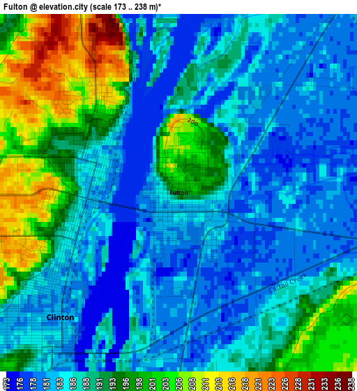
Below is the Elevation map of Fulton, which displays elevation range with different colors. Scale of the first map is from 173 to 238 m (568 to 781 ft) with average elevation of 188.5 meters (=618 ft) [note 1]
These maps also provides idea of topography and contour of this city, they are displayed at different zoom levels. More info about maps, scale and edge coordinates you can find below images.
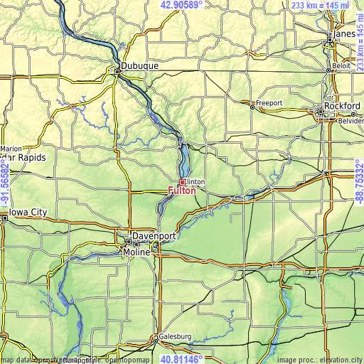
| \ | Map #1 | Topo.Map |
| Scale [m] | 173..238 m | × |
| Scale [ft] | 568..781 ft | × |
| Average | 188.5 m = 618 ft | × |
| Width | 7.28 km = 4.5 mi | 232.9 km = 144.7 mi |
| Height | 7.28 km = 4.5 mi | 232.9 km = 144.7 mi |
| ↑Max Latitude | 41.899967° | 42.90589° |
| Latitude at center | 41.86725° | 41.86725° |
| ↓Min Latitude | 41.834516° | 40.81146° |
| ← Min Longitude | -90.203515° | -91.56582° |
| Longitude center | -90.15957° | -90.15957° |
| →Max Longitude | -90.115625° | -88.75332° |
Nearby cities:
Cities around Fulton sort by population:
• Clinton elevation 181 m
3.5 km,  223°
223°
• De Witt 219 m
31.7 km,  261°
261°
• Camanche 182 m
11.9 km, 222°
• Morrison 209 m
17.3 km,  111°
111°
• Le Claire 181 m
33.5 km,  207°
207°
• Savanna 184 m
25.3 km,  0°
0°
• Park View 238 m
37.4 km,  238°
238°
• Prophetstown 191 m
28.6 km,  139°
139°
• Port Byron 191 m
32.5 km, 206°
• Mount Carroll 247 m
29.4 km,  30°
30°
• Erie 183 m
24.4 km,  164°
164°
• Preston 196 m
29.3 km,  314°
314°
Multilingual:
 En español:
Fulton elevación 199 m.
 En France:
Fulton élévation 199 m.


Sources and notes:
- [note 1] Map square and city borders are not equal. Map elevation data is calculated only from area inside that square.
- [src 1] Elevation data from geonames database provided with same terms of usage.
- [src 2] The elevation map of Fulton is generated using elevation data from NASA's 3 arcsec (90m) resolution SRTM data.
- [src 3] Base (background) map © OpenStreetMap contributors tiles are generated by Geofabrik and OpenTopoMap.
Copyright & License:
This Fulton Elevation Map is licensed under CC BY-SA. You may reuse any part from this page, if you give a proper credit by linking to this URL:
 More info on terms of use page.