Prophetstown elevation
Prophetstown (Illinois, Whiteside County), United States elevation is 191 meters and Prophetstown elevation in feet is 627 ft above sea level [src 1]. Prophetstown is a populated place (feature code) with elevation that is 88 meters (289 ft) smaller than average city elevation in United States.
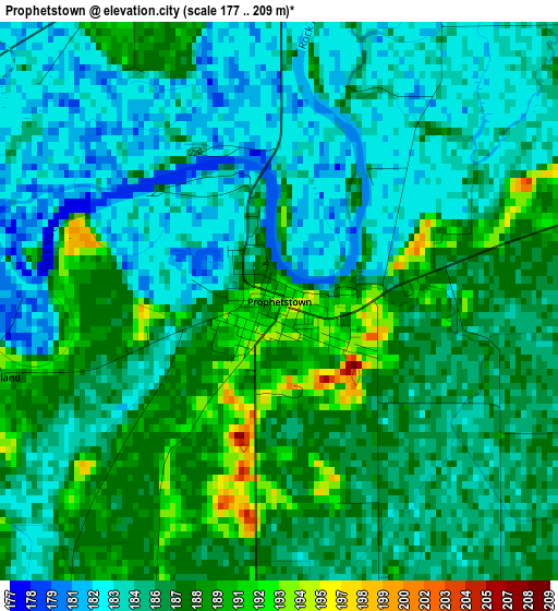
Below is the Elevation map of Prophetstown, which displays elevation range with different colors. Scale of the first map is from 177 to 209 m (581 to 686 ft) with average elevation of 185.8 meters (=610 ft) [note 1]
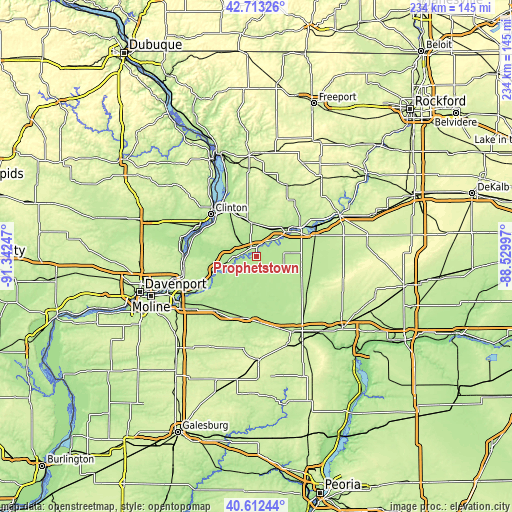
These maps also provides idea of topography and contour of this city, they are displayed at different zoom levels. More info about maps, scale and edge coordinates you can find below images.
| \ | Map #1 | Topo.Map |
| Scale [m] | 177..209 m | × |
| Scale [ft] | 581..686 ft | × |
| Average | 185.8 m = 610 ft | × |
| Width | 7.3 km = 4.5 mi | 233.6 km = 145.2 mi |
| Height | 7.3 km = 4.5 mi | 233.6 km = 145.2 mi |
| ↑Max Latitude | 41.704237° | 42.71326° |
| Latitude at center | 41.67142° | 41.67142° |
| ↓Min Latitude | 41.638586° | 40.61244° |
| ← Min Longitude | -89.980165° | -91.34247° |
| Longitude center | -89.93622° | -89.93622° |
| →Max Longitude | -89.892275° | -88.52997° |
Nearby cities:
Cities around Prophetstown sort by population:
• Clinton elevation 181 m
28.4 km,  312°
312°
• Sterling 203 m
23.8 km,  56°
56°
• Rock Falls 200 m
23.8 km, 59°
• Geneseo 201 m
30.8 km,  216°
216°
• Colona 186 m
40.5 km,  238°
238°
• Camanche 182 m
29.6 km,  296°
296°
• Morrison 209 m
15.6 km,  351°
351°
• Le Claire 181 m
34.8 km,  256°
256°
• Fulton 199 m
28.6 km,  319°
319°
• Port Byron 191 m
33.9 km, 257°
• Erie 183 m
12 km, 262°
• Walnut 213 m
31.2 km,  114°
114°
Multilingual:
 En español:
Prophetstown elevación 191 m.
 En France:
Prophetstown élévation 191 m.
 Auf Deutsch:
Prophetstown höhe über dem Meeresspiegel ist 191 m.

Sources and notes:
- [note 1] Map square and city borders are not equal. Map elevation data is calculated only from area inside that square.
- [src 1] Elevation data from geonames database provided with same terms of usage.
- [src 2] The elevation map of Prophetstown is generated using elevation data from NASA's 3 arcsec (90m) resolution SRTM data.
- [src 3] Base (background) map © OpenStreetMap contributors tiles are generated by Geofabrik and OpenTopoMap.
Copyright & License:
This Prophetstown Elevation Map is licensed under CC BY-SA. You may reuse any part from this page, if you give a proper credit by linking to this URL:
 More info on terms of use page.